IMAGES TAKEN NEAR TO
Maple Court, NORTHALLERTON, DL7 8WJ
Introduction
This page details the photographs taken nearby to Maple Court, DL7 8WJ by members of the Geograph project.
The Geograph project started in 2005 with the aim of publishing, organising and preserving representative images for every square kilometre of Great Britain, Ireland and the Isle of Man.

There are currently over 7.5m images from over14,400 individuals and you can help contribute to the project by visiting https://www.geograph.org.uk
Image Map
Images are licensed for reuse under creativecommons.org/licenses/by-sa/2.0
Notes
- Clicking on the map will re-center to the selected point.
- The higher the marker number, the further away the image location is from the centre of the postcode.
Image Listing (33 Images Found)
Images are licensed for reuse under creativecommons.org/licenses/by-sa/2.0
Image
Details
Distance
1
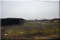
York Containers Factory
It was a red-letter day when York-Trailers (as everyone called them) built a factory on green fields at the north end of the town to construct containers for road, rail and ship use.
That was 40 years ago - during my teens.
Now the empty shell lies abandoned.
Image: © Bob Embleton
Taken: 2 Jul 2010
0.03 miles
2
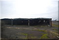
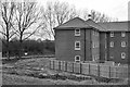
Derelict building on the edge of Northallerton
Image: © N Chadwick
Taken: 25 Feb 2011
0.05 miles
4
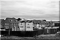
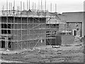
New Housing Development at Mowbray Park
Image: © David Dixon
Taken: 22 Mar 2016
0.06 miles
5
Derelict factory in northern Northallerton
Image: © N Chadwick
Taken: 21 Feb 2011
0.07 miles
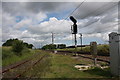
6
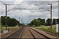
East Coast Main Line, Castle Hills, Northallerton
Looking north towards Darlington, Newcastle and Edinburgh.
On the left is the Castle Hills Junction where the old mineral trains used to come down the Hawes branch line each evening, in my 1960s youth, then reverse down the main line into Northallerton station before heading out to Teeside on the Middlesbrough line.
The old brick Zetland Bridge has been replaced with the blue metal version to accommodate the overhead electric wires.
Image: © Bob Embleton
Taken: 2 Jul 2010
0.08 miles
8
Old Northallerton U.D.C. refuse tip
The field beyond the one in the foreground used to be a landfill site used by the urban district council for household and other refuse.
Some day this will be an archaeologists heaven.
I spent much time here during a summer job with the council in 1970.
As well as general household dustbin-collection waste we had:
a load of ex-rental TVs (from which I removed many components),
dead deer hit by vehicles on the A19,
a weekly load of animal parts and revolting stomach contents from the abattoir in The Applegarth
and tons of clinker from the ballast bed of the old wartime "austerity" railway line.
The latter was an attempt to reduce the fly population that was causing discomfort to the workers at the nearby new York Containers factory.
Happy days!
Image: © Bob Embleton
Taken: 2 Jul 2010
0.11 miles
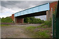
9
Hawes branch line junction, Castle Hills, Northallerton
The old rusty single line from Hawes runs along side the electrified east coast main line. The modern blue metal bridge replaces the old brick Zetland Bridge.
Image: © Bob Embleton
Taken: 2 Jul 2010
0.11 miles
10
East Coast Main line under Zetland Bridge
There was an Ordnance Survey benchmark on an earlier (1840s) bridge at this site, see http://www.bench-marks.org.uk/bm84781 for details
Image: © Roger Templeman
Taken: 11 Jun 2017
0.12 miles