IMAGES TAKEN NEAR TO
Finkills Way, NORTHALLERTON, DL7 8UB
Introduction
This page details the photographs taken nearby to Finkills Way, DL7 8UB by members of the Geograph project.
The Geograph project started in 2005 with the aim of publishing, organising and preserving representative images for every square kilometre of Great Britain, Ireland and the Isle of Man.

There are currently over 7.5m images from over14,400 individuals and you can help contribute to the project by visiting https://www.geograph.org.uk
Image Map
Images are licensed for reuse under creativecommons.org/licenses/by-sa/2.0
Notes
- Clicking on the map will re-center to the selected point.
- The higher the marker number, the further away the image location is from the centre of the postcode.
Image Listing (61 Images Found)
Images are licensed for reuse under creativecommons.org/licenses/by-sa/2.0
Image
Details
Distance
1
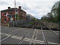
Northallerton Town railway station (site), Yorkshire
Opened in 1852 by the Leeds Northern Railway, soon to become part of the North Eastern Railway, on the line from Leeds to Middlesbrough, this short-lived station closed in 1856 when trains were diverted into the current station.
View south west from Low Gates level-crossing towards the junction with the East Coast Main Line and the location of the current station.
Image: © Nigel Thompson
Taken: 19 May 2015
0.06 miles
2
Low Gates crossing the line to Teeside
Taken from the narrow footbridge.
To the right before the crossing there used to be a goods yard with raised coal depositing lines where lorries could load up beneath the wagons.
Image: © Bob Embleton
Taken: 2 Jul 2010
0.07 miles
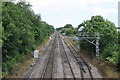
3
Low Gates Crossing, Northallerton
A familiar sight at this busy crossing on the Northallerton to Middlesbrough line.
Image: © Tony Simms
Taken: 6 May 2015
0.08 miles

5
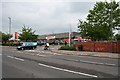
Sainsbury's, North End
Located at the far north end of the High Street near to the Low Gates level crossing on land that was once the railway marshalling yards.
Image: © Bob Embleton
Taken: 18 Jun 2007
0.08 miles
6
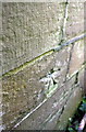
Benchmark on the back of the NE parapet of North Bridge
This Ordnance Survey 1GL bolt benchmark which is described on the Bench Mark Database at http://www.bench-marks.org.uk/bm26133 was cut during the levelling of the Selby to Newcastle-upon-Tyne line during 1842-1845.
Image: © Roger Templeman
Taken: 27 May 2012
0.08 miles
7
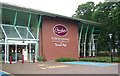
Furnishing Store
This is a modern furnishing store standing in quiet and pleasant surroundings.
It features what has been called the ' Terrace Cafe ', a facility which can refresh customers and travellers alike.
Image: © Geoff Royle
Taken: 12 Jun 2007
0.08 miles
8
Traffic waits on North Bridge for a diesel multiple unit
The DMU is Class 185 number 185 103. On the left hand edge of the image is an OS flush bracket fixed in the bridge parapet with an EA bolt in the pavement just to its right Image
Image: © Roger Templeman
Taken: 27 May 2012
0.09 miles
9
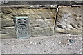
Two benchmarks on North Bridge
There is an Environment Agency Bench Mark bolt to the right of an Ordnance Survey flush bracket serial number 2158 which is described on the Bench Mark Database at http://www.bench-marks.org.uk/bm10195
There is a third older (1840s) OS benchmark on the back of the parapet Image
Image: © Roger Templeman
Taken: 27 May 2012
0.09 miles
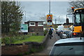
10
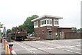
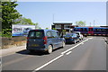
Low Gates Level Crossing and Signal Box
Here the railway from Northallerton to Middlesbrough crosses the busy A167 Darlington Road causing traffic chaos. For more on the signal box see:-http://www.signalbox.org/gallery/ne/lowgates.htm
Image: © Bob Embleton
Taken: 18 Jun 2007
0.09 miles