IMAGES TAKEN NEAR TO
Allerton Way, NORTHALLERTON, DL7 8ND
Introduction
This page details the photographs taken nearby to Allerton Way, DL7 8ND by members of the Geograph project.
The Geograph project started in 2005 with the aim of publishing, organising and preserving representative images for every square kilometre of Great Britain, Ireland and the Isle of Man.

There are currently over 7.5m images from over14,400 individuals and you can help contribute to the project by visiting https://www.geograph.org.uk
Image Map
Images are licensed for reuse under creativecommons.org/licenses/by-sa/2.0
Notes
- Clicking on the map will re-center to the selected point.
- The higher the marker number, the further away the image location is from the centre of the postcode.
Image Listing (82 Images Found)
Images are licensed for reuse under creativecommons.org/licenses/by-sa/2.0
Image
Details
Distance
1
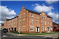
Flats at Allerton Way / Romanby Road junction
Image: © Roger Templeman
Taken: 7 Sep 2014
0.02 miles
2
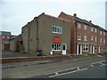
The WJO (Pop) Lewis Memorial Band Room
This is the home of Northallerton District Silver Band.
The houses next door were built in 2005 and take the place of the Allerton Industries steel fabrication factory.
Image: © Nick W
Taken: 24 Dec 2008
0.04 miles
3
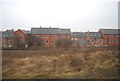
New houses on Allerton Close
Seen from the ECML.
Image: © N Chadwick
Taken: 21 Feb 2011
0.04 miles
4
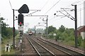
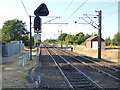
Railway Junction, North of Northallerton Station.
Viewed from the end of the north bound platform. Straight ahead is the east coast main line to Darlington, Newcastle and Edinburgh. The train in view, however is dropping down to pass through "Low Gates" and head towards Middlesbrough.
Image: © Bob Embleton
Taken: 19 Jun 2007
0.09 miles
5
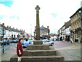
Market Cross, Northallerton
Plaque refers to it being an "Ancient" market cross restored in 1914. With the Town Hall in the background.
Image: © Bob Embleton
Taken: 31 May 2001
0.09 miles
6
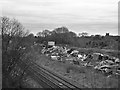
Rubbish Tipped next to the Railway Track at Northallerton
Image: © David Dixon
Taken: 22 Mar 2016
0.10 miles
7
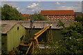
Engineering works, Northallerton, from the railway
Image: © Christopher Hilton
Taken: 12 Jul 2015
0.10 miles
8
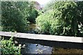
The Willow Beck
Looking downstream as the beck follows the industrial area of Springwell Lane.
The concrete protects pipes over the stream and an important place to fish for minnows and sticklebacks as well as aerial bombardment of enemy twigs.
Here I would carry out many civil engineering projects in my early years - despite rubbish (including a broken vacuum flask) being tossed over the wall from the workers next door.
It now looks very overgrown and unplayed in.
Image: © Bob Embleton
Taken: 2 Jul 2010
0.11 miles
9
Northallerton station - East Coast Main Line to the north
In the middle distance, two separate lines lead on to the Middlesbrough line (there is also an avoiding line under the mainline tracks for fast trains to this branch).
Image: © Stephen Craven
Taken: 14 Jul 2018
0.11 miles
10
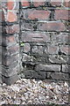
Benchmark on railway bridge, Romanby Road
Ordnance Survey cut mark benchmark described on the Bench Mark Database at http://www.bench-marks.org.uk/bm43113
Image: © Roger Templeman
Taken: 20 May 2012
0.11 miles