IMAGES TAKEN NEAR TO
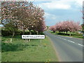
Pennine View, NORTHALLERTON, DL7 8HN
Introduction
This page details the photographs taken nearby to Pennine View, DL7 8HN by members of the Geograph project.
The Geograph project started in 2005 with the aim of publishing, organising and preserving representative images for every square kilometre of Great Britain, Ireland and the Isle of Man.

There are currently over 7.5m images from over14,400 individuals and you can help contribute to the project by visiting https://www.geograph.org.uk
Image Map
Images are licensed for reuse under creativecommons.org/licenses/by-sa/2.0
Notes
- Clicking on the map will re-center to the selected point.
- The higher the marker number, the further away the image location is from the centre of the postcode.
Image Listing (29 Images Found)
Images are licensed for reuse under creativecommons.org/licenses/by-sa/2.0
Image
Details
Distance
1
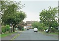
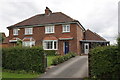
Pennine View, Romanby
Typical suburban avenue with houses of the 1960's and 70's. I think the road name is rather wishful thinking.
Image: © Gordon Hatton
Taken: 13 Jun 2020
0.01 miles
2
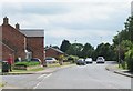
Ainderby Road, Romanby
In the left foreground are a pair of houses recently constructed on the corner of The Link. Ainderby Road is the B1333 heading towards a junction with the A684.
Image: © Gordon Hatton
Taken: 8 Jun 2020
0.10 miles
4
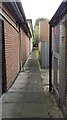
Passageway along north side of Coop Store, Boroughbridge Road
Formerly this was the site of #36 Boroughbridge Road which had an Ordnance Survey benchmark levelled at 40.565m above Newlyn Datum verified in 1972
Image: © Roger Templeman
Taken: 26 Sep 2021
0.18 miles
5
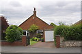
#58 Ainderby Road with detached garage
There is an OS benchmark Image on the garage to the left of its door and below the house number
Image: © Roger Templeman
Taken: 17 Jun 2012
0.19 miles
6
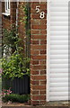
Benchmark on the garage of #58 Ainderby Road
Ordnance Survey cut mark benchmark described on the Bench Mark Database at http://www.bench-marks.org.uk/bm32997
Image: © Roger Templeman
Taken: 17 Jun 2012
0.19 miles
8
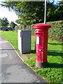
Postbox, Romanby
A George VI reign postbox at the junction of Boroughbridge Road and Harewood Lane.
Image: © Maigheach-gheal
Taken: 4 Oct 2010
0.20 miles
10
Semi-detached houses on Lees Lane
The right hand house (#47) has an OS benchmark Image to the right of its front door
Image: © Roger Templeman
Taken: 17 Jun 2012
0.21 miles