IMAGES TAKEN NEAR TO
St. James Road, NORTHALLERTON, DL7 8HH
Introduction
This page details the photographs taken nearby to St. James Road, DL7 8HH by members of the Geograph project.
The Geograph project started in 2005 with the aim of publishing, organising and preserving representative images for every square kilometre of Great Britain, Ireland and the Isle of Man.

There are currently over 7.5m images from over14,400 individuals and you can help contribute to the project by visiting https://www.geograph.org.uk
Image Map
Images are licensed for reuse under creativecommons.org/licenses/by-sa/2.0
Notes
- Clicking on the map will re-center to the selected point.
- The higher the marker number, the further away the image location is from the centre of the postcode.
Image Listing (27 Images Found)
Images are licensed for reuse under creativecommons.org/licenses/by-sa/2.0
Image
Details
Distance
1
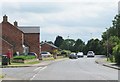
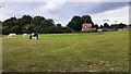
Ainderby Road, Romanby
In the left foreground are a pair of houses recently constructed on the corner of The Link. Ainderby Road is the B1333 heading towards a junction with the A684.
Image: © Gordon Hatton
Taken: 8 Jun 2020
0.04 miles
2
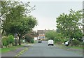
Pennine View, Romanby
Typical suburban avenue with houses of the 1960's and 70's. I think the road name is rather wishful thinking.
Image: © Gordon Hatton
Taken: 13 Jun 2020
0.07 miles
4
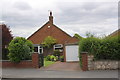
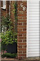
#58 Ainderby Road with detached garage
There is an OS benchmark Image on the garage to the left of its door and below the house number
Image: © Roger Templeman
Taken: 17 Jun 2012
0.13 miles
5
Benchmark on the garage of #58 Ainderby Road
Ordnance Survey cut mark benchmark described on the Bench Mark Database at http://www.bench-marks.org.uk/bm32997
Image: © Roger Templeman
Taken: 17 Jun 2012
0.13 miles
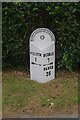
7
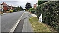
Looking SW along Ainderby Road at 1 mile from Northallerton and 7 miles from Bedale
The North Riding of Yorkshire milestone Image on the verge beside the holly hedge looks good having been repainted in 2021
Image: © Roger Templeman
Taken: 25 Aug 2024
0.16 miles
8
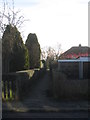
Footpath to The Close from Ainderby Road
Provides access to Romanby Primary School and the Women's Institute Hall from Ainderby Road.
Image: © Jonathan Thacker
Taken: 29 Nov 2012
0.17 miles
9
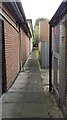
Passageway along north side of Coop Store, Boroughbridge Road
Formerly this was the site of #36 Boroughbridge Road which had an Ordnance Survey benchmark levelled at 40.565m above Newlyn Datum verified in 1972
Image: © Roger Templeman
Taken: 26 Sep 2021
0.18 miles
10
Old milepost
The rusty milepost on Ainderby Road out of Northallerton, B1333, has been painted during summer 2021. The holly hedge has been trimmed back and the verge cleared so now all the raised legends are clear to read.
Image: © Hilary Jones
Taken: 12 Sep 2021
0.19 miles