IMAGES TAKEN NEAR TO
Low Street, NORTHALLERTON, DL7 0SW
Introduction
This page details the photographs taken nearby to Low Street, DL7 0SW by members of the Geograph project.
The Geograph project started in 2005 with the aim of publishing, organising and preserving representative images for every square kilometre of Great Britain, Ireland and the Isle of Man.

There are currently over 7.5m images from over14,400 individuals and you can help contribute to the project by visiting https://www.geograph.org.uk
Image Map
Images are licensed for reuse under creativecommons.org/licenses/by-sa/2.0
Notes
- Clicking on the map will re-center to the selected point.
- The higher the marker number, the further away the image location is from the centre of the postcode.
Image Listing (12 Images Found)
Images are licensed for reuse under creativecommons.org/licenses/by-sa/2.0
Image
Details
Distance
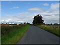
1
Low Street, heading south-east towards Melton House
With snowdrops flowering on the verge.
Image: © Christine Johnstone
Taken: 23 Mar 2018
0.04 miles

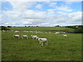
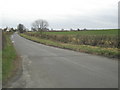
3
Farmland, north-west of Melton House
On the west side of Low Street.
Image: © Christine Johnstone
Taken: 23 Mar 2018
0.07 miles
4
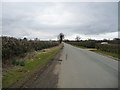
Low Street heading north-west to a 49 metre spot height
Approximately parallel to the A1(M), but almost a kilometre east.
Image: © Christine Johnstone
Taken: 23 Mar 2018
0.09 miles
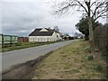
5
Low Street near Melton House
Towards Glebe Farm.
Image: © JThomas
Taken: 24 Jul 2020
0.09 miles
7
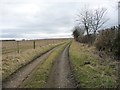
Farm track, south of Glebe Farm
Running west from Low Street.
Image: © Christine Johnstone
Taken: 23 Mar 2018
0.10 miles
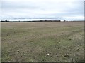
8
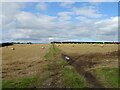
Farm track over stubble field
Off Low Street.
Image: © JThomas
Taken: 24 Jul 2020
0.12 miles
9
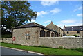
Melton House
Showing position of Postbox No. DL7 145.
See Image] for postbox.
Image: © JThomas
Taken: 24 Jul 2020
0.17 miles