IMAGES TAKEN NEAR TO
Thrintoft, NORTHALLERTON, DL7 0QA
Introduction
This page details the photographs taken nearby to DL7 0QA by members of the Geograph project.
The Geograph project started in 2005 with the aim of publishing, organising and preserving representative images for every square kilometre of Great Britain, Ireland and the Isle of Man.

There are currently over 7.5m images from over14,400 individuals and you can help contribute to the project by visiting https://www.geograph.org.uk
Image Map
Images are licensed for reuse under creativecommons.org/licenses/by-sa/2.0
Notes
- Clicking on the map will re-center to the selected point.
- The higher the marker number, the further away the image location is from the centre of the postcode.
Image Listing (12 Images Found)
Images are licensed for reuse under creativecommons.org/licenses/by-sa/2.0
Image
Details
Distance
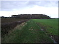
1
Access to Bowes Hill
Access lane leading off Moor Lane - the B6271 Northallerton/Richmond Road
Image: © Chris Heaton
Taken: 18 Aug 2020
0.06 miles
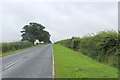
2
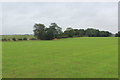
Pasture on Yafforth Moor
As seen from Moor Lane - the B6271 Northallerton/Richmond Road
Image: © Chris Heaton
Taken: 18 Aug 2020
0.08 miles
5
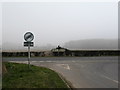
Junction of the B6271 with Thrintoft Moor lane
A misty spring morning in the countryside near Yafforth.
Image: © Gordon Hatton
Taken: 28 Mar 2007
0.14 miles
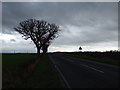
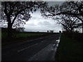
6
Moor Lane heading towards Yafforth
Near death experience happened here.
Turning right on my bicycle after checking behind. I heard the car behind slow down. Quarter of the way across opposite side of the road when another car at very high speed overtook, swerving onto the grass verge. It had disappeared before I could gather my wits. It missed me by millimetres. The occupants of the first car looked absolutely astonished.
Next time I will stop on the left, and walk across the road, when it is clear.
Image: © Chris Heaton
Taken: 18 Aug 2020
0.16 miles
7
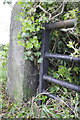
Benchmark on gatepost beside B6271 at Yafforth Moor
Ordnance Survey cut mark benchmark described on the Bench Mark Database at http://www.bench-marks.org.uk/bm48763
Image: © Roger Templeman
Taken: 27 May 2013
0.16 miles
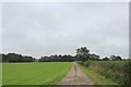
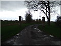
8
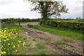
Farm track leading to B6271, Moor Lane
There is an OS benchmark Image on the stone gatepost by the metal gate
Image: © Roger Templeman
Taken: 27 May 2013
0.16 miles