IMAGES TAKEN NEAR TO
Danby Wiske, NORTHALLERTON, DL7 0NL
Introduction
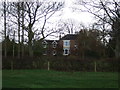
This page details the photographs taken nearby to DL7 0NL by members of the Geograph project.
The Geograph project started in 2005 with the aim of publishing, organising and preserving representative images for every square kilometre of Great Britain, Ireland and the Isle of Man.

There are currently over 7.5m images from over14,400 individuals and you can help contribute to the project by visiting https://www.geograph.org.uk
Image Map
Images are licensed for reuse under creativecommons.org/licenses/by-sa/2.0
Notes
- Clicking on the map will re-center to the selected point.
- The higher the marker number, the further away the image location is from the centre of the postcode.
Image Listing (2 Images Found)
Images are licensed for reuse under creativecommons.org/licenses/by-sa/2.0
Image
Details
Distance
1
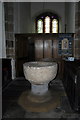
Norman Font, Danby Wiske Parish Church
"This simple but massive stone font is one of a very few in this area to survive from early times. Such symbols of the Roman Church were a popular target for destruction by extremists during both the Reformation and Cromwell's Protectorate. This font must have been carefully hidden away until the threat from iconoclasts had abated".
Image: © David Rogers
Taken: 30 May 2012
0.24 miles