IMAGES TAKEN NEAR TO
Danby Wiske, NORTHALLERTON, DL7 0NF
Introduction
This page details the photographs taken nearby to DL7 0NF by members of the Geograph project.
The Geograph project started in 2005 with the aim of publishing, organising and preserving representative images for every square kilometre of Great Britain, Ireland and the Isle of Man.

There are currently over 7.5m images from over14,400 individuals and you can help contribute to the project by visiting https://www.geograph.org.uk
Image Map
Images are licensed for reuse under creativecommons.org/licenses/by-sa/2.0
Notes
- Clicking on the map will re-center to the selected point.
- The higher the marker number, the further away the image location is from the centre of the postcode.
Image Listing (18 Images Found)
Images are licensed for reuse under creativecommons.org/licenses/by-sa/2.0
Image
Details
Distance
1
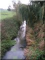
River Wiske near Danby
The view downstream from Wiske Bridge.
Image: © Dave Dunford
Taken: 25 Oct 2006
0.03 miles
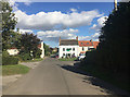
2
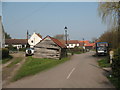
Village Street, Danby Wiske
A quiet village street and rather 'rustic' wooden barn.
Image: © Gordon Hatton
Taken: 28 Mar 2007
0.03 miles
4
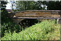
Wiske Bridge, taking Danby Lane over River Wiske
There is an OS benchmark Image on the right hand side of the bridge arch, hidden by the bankside vegetation in this image.
Image: © Roger Templeman
Taken: 25 Jun 2017
0.07 miles
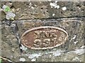
5
Benchmark on Danby Wiske Bridge
Ordnance Survey 1GL bolt benchmark described on the Bench Mark Database at http://www.bench-marks.org.uk/bm85852
Image: © Roger Templeman
Taken: 25 Jun 2017
0.07 miles
6
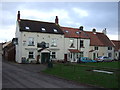
Danby Wiske
The small settlement, particularly its pub, The White Swan seen here, is much affected by the influx of walkers on Wainwright's Coast to Coast route.
Image: © John Allan
Taken: 12 Sep 2018
0.07 miles
7
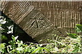
Bridge Marker on Wiske Bridge, Danby Wiske
North Riding bridge number at the east end of the south parapet of Wiske Bridge, River Wiske on Danby Lane. Danby Wiske with Lazenby parish.
Milestone Society National ID: YN_WISKE01br
Image: © D Phillips
Taken: 14 Jul 2021
0.08 miles
8
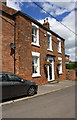
'Glenfield', Dandy Lane
There is an OS benchmark Image in bricks on the front of the house on the near side of the door.
Image: © Roger Templeman
Taken: 25 Jun 2017
0.09 miles
9
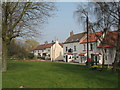
Village Green at Danby Wiske
The green is at the centre of this pleasant village near Northallerton.
Image: © Gordon Hatton
Taken: 28 Mar 2007
0.09 miles
10

Benchmark on 'Glenfield', Danby Lane
Ordnance Survey cut mark benchmark described on the Bench Mark Database at http://www.bench-marks.org.uk/bm86349
Image: © Roger Templeman
Taken: 25 Jun 2017
0.09 miles