IMAGES TAKEN NEAR TO
Danby Wiske, NORTHALLERTON, DL7 0LU
Introduction
This page details the photographs taken nearby to DL7 0LU by members of the Geograph project.
The Geograph project started in 2005 with the aim of publishing, organising and preserving representative images for every square kilometre of Great Britain, Ireland and the Isle of Man.

There are currently over 7.5m images from over14,400 individuals and you can help contribute to the project by visiting https://www.geograph.org.uk
Image Map
Images are licensed for reuse under creativecommons.org/licenses/by-sa/2.0
Notes
- Clicking on the map will re-center to the selected point.
- The higher the marker number, the further away the image location is from the centre of the postcode.
Image Listing (8 Images Found)
Images are licensed for reuse under creativecommons.org/licenses/by-sa/2.0
Image
Details
Distance
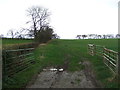
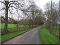
1
Road through park land at Little Danby Hall
Neatly trimmed verges and parkland to either side of the road here close to Little Danby Hall, the garden wall of which is seen to the left.
Image: © Gordon Hatton
Taken: 26 Sep 2018
0.03 miles
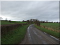
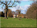
2
Near Little Danby Hall
Looking east from the road.
Image: © T Eyre
Taken: 29 May 2019
0.04 miles
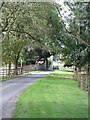
4
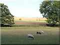
Sheep grazing at Little Danby Hall
Pasture land close to Little Danby Hall with arable fields beyond.
Image: © Gordon Hatton
Taken: 26 Sep 2018
0.07 miles
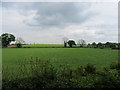
6
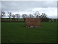
Small agricultural building off Mounstrall Lane
Image: © JThomas
Taken: 26 Nov 2011
0.11 miles