IMAGES TAKEN NEAR TO
Yafforth Road, NORTHALLERTON, DL7 0LQ
Introduction
This page details the photographs taken nearby to Yafforth Road, DL7 0LQ by members of the Geograph project.
The Geograph project started in 2005 with the aim of publishing, organising and preserving representative images for every square kilometre of Great Britain, Ireland and the Isle of Man.

There are currently over 7.5m images from over14,400 individuals and you can help contribute to the project by visiting https://www.geograph.org.uk
Image Map
Images are licensed for reuse under creativecommons.org/licenses/by-sa/2.0
Notes
- Clicking on the map will re-center to the selected point.
- The higher the marker number, the further away the image location is from the centre of the postcode.
Image Listing (3 Images Found)
Images are licensed for reuse under creativecommons.org/licenses/by-sa/2.0
Image
Details
Distance
1
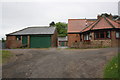
Buildings at Jeckelow Grange
There is an OS benchmark Image on the left hand face near corner of the garage block
Image: © Roger Templeman
Taken: 12 May 2013
0.00 miles
2
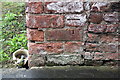
Benchmark on Jeckelow Grange garage block
Ordnance Survey cut mark benchmark described on the Bench Mark Database at http://www.bench-marks.org.uk/bm48533
Image: © Roger Templeman
Taken: 12 May 2013
0.01 miles
3
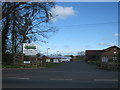
Entrance to Northdale Garden Nursery and Shop from Yafforth Road
Image: © Peter Robinson
Taken: 15 Apr 2012
0.06 miles