IMAGES TAKEN NEAR TO
East Cowton, NORTHALLERTON, DL7 0JW
Introduction
This page details the photographs taken nearby to DL7 0JW by members of the Geograph project.
The Geograph project started in 2005 with the aim of publishing, organising and preserving representative images for every square kilometre of Great Britain, Ireland and the Isle of Man.

There are currently over 7.5m images from over14,400 individuals and you can help contribute to the project by visiting https://www.geograph.org.uk
Image Map
Images are licensed for reuse under creativecommons.org/licenses/by-sa/2.0
Notes
- Clicking on the map will re-center to the selected point.
- The higher the marker number, the further away the image location is from the centre of the postcode.
Image Listing (4 Images Found)
Images are licensed for reuse under creativecommons.org/licenses/by-sa/2.0
Image
Details
Distance
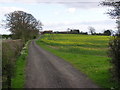
2
Footpath at Corn Hill
Another path [number 10.41/6] that appears to see little use as there's no marked line on the ground. The fence to the left doesn't appear on the map and looks temporary, whilst the path on the opposite side of Raby Lane doesn't seem to exist at all.
Image: © Gordon Hatton
Taken: 10 Sep 2020
0.17 miles
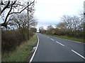
4
Raby Lane
Heading south towards East Cowton.
Image: © JThomas
Taken: 14 Nov 2015
0.25 miles