IMAGES TAKEN NEAR TO
South Cowton, NORTHALLERTON, DL7 0JB
Introduction
This page details the photographs taken nearby to DL7 0JB by members of the Geograph project.
The Geograph project started in 2005 with the aim of publishing, organising and preserving representative images for every square kilometre of Great Britain, Ireland and the Isle of Man.

There are currently over 7.5m images from over14,400 individuals and you can help contribute to the project by visiting https://www.geograph.org.uk
Image Map
Images are licensed for reuse under creativecommons.org/licenses/by-sa/2.0
Notes
- Clicking on the map will re-center to the selected point.
- The higher the marker number, the further away the image location is from the centre of the postcode.
Image Listing (15 Images Found)
Images are licensed for reuse under creativecommons.org/licenses/by-sa/2.0
Image
Details
Distance
1
View from Atley Hill
Towards Cowton Castle (Image) see https://en.wikipedia.org/wiki/South_Cowton_Castle
Image: © Mick Garratt
Taken: 28 May 2016
0.12 miles
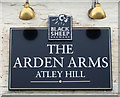
2
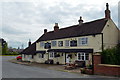
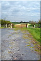
The Arden Arms, Atley Hill (or South Cowton)
Image: © Tony Simms
Taken: 13 May 2015
0.13 miles
6
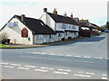
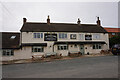
The Arden Arms at Atley Hill
Closed for the present; presumably for refurbishment. On the B1269
Image: © Oliver Dixon
Taken: 29 Mar 2006
0.14 miles
7
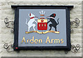
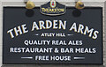
Coat of arms sign on the Arden Arms, Atley Hill
Image: © JThomas
Taken: 14 Nov 2015
0.14 miles
9
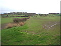
Original line of Scorton - Cowtons road
The road junction at Atley Hill was originally the opposite to what it is now. The road from Streatlam to Cowtons was the main road and the Scorton road was the side road. Around 1930 the road seems to have been realigned to give a smoother corner and to make the Streatlam road the side one. The other end of the realignment can be seen at the top of the grid square.
Image: © Tony Simms
Taken: 13 May 2015
0.17 miles
10
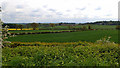
Fields and hedgerow, Atley Hill
Off the B1263.
Image: © JThomas
Taken: 14 Nov 2015
0.17 miles