IMAGES TAKEN NEAR TO
North Cowton, NORTHALLERTON, DL7 0HJ
Introduction
This page details the photographs taken nearby to DL7 0HJ by members of the Geograph project.
The Geograph project started in 2005 with the aim of publishing, organising and preserving representative images for every square kilometre of Great Britain, Ireland and the Isle of Man.

There are currently over 7.5m images from over14,400 individuals and you can help contribute to the project by visiting https://www.geograph.org.uk
Image Map
Images are licensed for reuse under creativecommons.org/licenses/by-sa/2.0
Notes
- Clicking on the map will re-center to the selected point.
- The higher the marker number, the further away the image location is from the centre of the postcode.
Image Listing (4 Images Found)
Images are licensed for reuse under creativecommons.org/licenses/by-sa/2.0
Image
Details
Distance
1
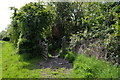
Gated crossing over disused railway
Similar shot to the first geograph here, the scene is substantially unchanged in eight years.
Image: © Tony Simms
Taken: 30 May 2015
0.20 miles
2
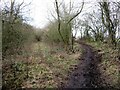
Bridleway and old rail track diverge
The former LNER Richmond branch rail track is seen here on the left, whilst to the right is bridleway number 20.52/7 heading towards North Cowton.
Image: © Gordon Hatton
Taken: 10 Feb 2023
0.21 miles
3
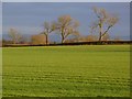
Farmland, North Cowton
Ash trees across an arable field viewed from the farm-road (bridleway) at Manor Farm.
Image: © Andrew Smith
Taken: 6 Jan 2012
0.21 miles
4
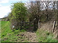
Gateing for the train that never comes!
(With apologies to Madness) This gate marks the point where the PF crosses the dismantled railway line SW of North Cowton.
Image: © Frank Glover
Taken: 11 Apr 2007
0.23 miles