IMAGES TAKEN NEAR TO
Danby Wiske, NORTHALLERTON, DL7 0AD
Introduction
This page details the photographs taken nearby to DL7 0AD by members of the Geograph project.
The Geograph project started in 2005 with the aim of publishing, organising and preserving representative images for every square kilometre of Great Britain, Ireland and the Isle of Man.

There are currently over 7.5m images from over14,400 individuals and you can help contribute to the project by visiting https://www.geograph.org.uk
Image Map
Images are licensed for reuse under creativecommons.org/licenses/by-sa/2.0
Notes
- Clicking on the map will re-center to the selected point.
- The higher the marker number, the further away the image location is from the centre of the postcode.
Image Listing (3 Images Found)
Images are licensed for reuse under creativecommons.org/licenses/by-sa/2.0
Image
Details
Distance
1
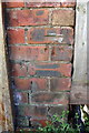
Benchmark on farm building, Park Hill
Ordnance Survey cut mark benchmark described on the Bench Mark Database at http://www.bench-marks.org.uk/bm86337
Image: © Roger Templeman
Taken: 25 Jun 2017
0.01 miles
2
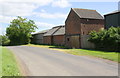
Farm buildings on Park Hill
There is an OS benchmark Image on bricks to the right of the sliding door of the building at the centre of the image
Image: © Roger Templeman
Taken: 25 Jun 2017
0.02 miles
3
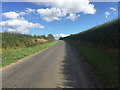
The road to Danby Wiske
Another section of tarmac on the flat part of Wainwright's Coast to Coast Walk across the Vale of Mowbray.
Image: © John Allan
Taken: 12 Sep 2018
0.16 miles