IMAGES TAKEN NEAR TO
Kirby Sigston, NORTHALLERTON, DL6 3TE
Introduction
This page details the photographs taken nearby to DL6 3TE by members of the Geograph project.
The Geograph project started in 2005 with the aim of publishing, organising and preserving representative images for every square kilometre of Great Britain, Ireland and the Isle of Man.

There are currently over 7.5m images from over14,400 individuals and you can help contribute to the project by visiting https://www.geograph.org.uk
Image Map
Images are licensed for reuse under creativecommons.org/licenses/by-sa/2.0
Notes
- Clicking on the map will re-center to the selected point.
- The higher the marker number, the further away the image location is from the centre of the postcode.
Image Listing (5 Images Found)
Images are licensed for reuse under creativecommons.org/licenses/by-sa/2.0
Image
Details
Distance
1
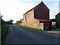
Smithy Farm, Kirby Sigston
The building beside the minor road has an Ordnance Survey flush bracket on it.
Image: © Maigheach-gheal
Taken: 24 Oct 2011
0.03 miles
3
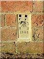
Flush Bracket 2163, Kirby Sigston
The Ordnance Survey flush bracket is to be found on the farm building shown in Image and for more information on the bracket and others in the area http://www.bench-marks.org.uk/bm65
Image: © Maigheach-gheal
Taken: 24 Oct 2011
0.03 miles
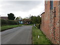
4
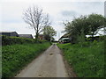
Foxton Lane
Near the crossroads, looking south,
Image: © T Eyre
Taken: 11 May 2018
0.04 miles