IMAGES TAKEN NEAR TO
Sandy Bank, NORTHALLERTON, DL6 3RW
Introduction
This page details the photographs taken nearby to Sandy Bank, DL6 3RW by members of the Geograph project.
The Geograph project started in 2005 with the aim of publishing, organising and preserving representative images for every square kilometre of Great Britain, Ireland and the Isle of Man.

There are currently over 7.5m images from over14,400 individuals and you can help contribute to the project by visiting https://www.geograph.org.uk
Image Map
Images are licensed for reuse under creativecommons.org/licenses/by-sa/2.0
Notes
- Clicking on the map will re-center to the selected point.
- The higher the marker number, the further away the image location is from the centre of the postcode.
Image Listing (18 Images Found)
Images are licensed for reuse under creativecommons.org/licenses/by-sa/2.0
Image
Details
Distance
1
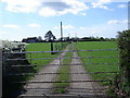
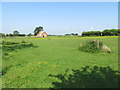
Entrance Gateway to High Thornborough Farm
Beyond the gate, the farm buildings of High Thornborough Farm. Taken from the country road SE of Northallerton.
Image: © Frank Glover
Taken: 17 Apr 2007
0.05 miles
2
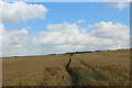
Track from High Thornborough to Sandy Banks
Looking northward
Image: © Peter Wood
Taken: 17 Oct 2014
0.06 miles
4
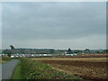
From the NE corner looking SE
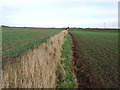
This is the Thornborough Farm Ploughing event that is held every year. It is right in the North Eastern corner of the square.
Image: © Nick W
Taken: 21 Sep 2003
0.10 miles
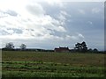
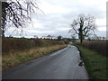
6
Sandy Bank
Looking along the road between Northallerton and Borrowby.
Image: © DS Pugh
Taken: 29 May 2016
0.15 miles
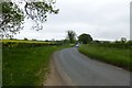
8
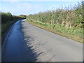
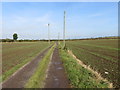
Road (Sandy Bank) approaching Northallerton
Looking north-westward.
Image: © Peter Wood
Taken: 17 Oct 2014
0.18 miles