IMAGES TAKEN NEAR TO
Scholla Lane, NORTHALLERTON, DL6 3QX
Introduction
This page details the photographs taken nearby to Scholla Lane, DL6 3QX by members of the Geograph project.
The Geograph project started in 2005 with the aim of publishing, organising and preserving representative images for every square kilometre of Great Britain, Ireland and the Isle of Man.

There are currently over 7.5m images from over14,400 individuals and you can help contribute to the project by visiting https://www.geograph.org.uk
Image Map
Images are licensed for reuse under creativecommons.org/licenses/by-sa/2.0
Notes
- Clicking on the map will re-center to the selected point.
- The higher the marker number, the further away the image location is from the centre of the postcode.
Image Listing (7 Images Found)
Images are licensed for reuse under creativecommons.org/licenses/by-sa/2.0
Image
Details
Distance
2
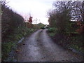
Bank Close Farm
Looking over my old home town of Northallerton from Scholla Lane with the pennines on the horizon.
Image: © Bob Embleton
Taken: 16 Dec 2006
0.06 miles
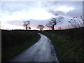
5
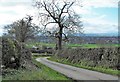
Scholla Lane
Narrow country lane that runs downhill to the housing estates on the east side of Northallerton.
Image: © Gordon Hatton
Taken: 4 Mar 2019
0.14 miles
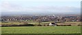
6
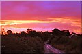
Awakening fox and hounds
Bullamoor road taken at dawn on way to the Fox and Hounds public house.
Image: © andy crossley
Taken: 4 Sep 2008
0.25 miles
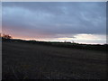
7
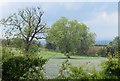
The missing hedgerow
The two trees in the field off Scholla Lane mark the line of a former hedge which is marked on my old 2005 edition OS map, but not on the current edition.
Image: © Gordon Hatton
Taken: 13 Jun 2020
0.25 miles