IMAGES TAKEN NEAR TO
Ingleby Cross, NORTHALLERTON, DL6 3NN
Introduction
This page details the photographs taken nearby to DL6 3NN by members of the Geograph project.
The Geograph project started in 2005 with the aim of publishing, organising and preserving representative images for every square kilometre of Great Britain, Ireland and the Isle of Man.

There are currently over 7.5m images from over14,400 individuals and you can help contribute to the project by visiting https://www.geograph.org.uk
Image Map (Loading...)


Getting Data...Please wait
Leaflet Map data © OpenStreetMap
Images are licensed for reuse under creativecommons.org/licenses/by-sa/2.0
Notes
- Clicking on the map will re-center to the selected point.
- The higher the marker number, the further away the image location is from the centre of the postcode.
Image Listing (5 Images Found)
Images are licensed for reuse under creativecommons.org/licenses/by-sa/2.0
Image
Details
Distance
1
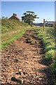
Approaching Summerfield Farm
On the Public Footpath from Fowgill Lane.
Image: © Mick Garratt
Taken: 10 Sep 2009
0.02 miles
2
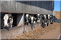
Cowshed, Summerfield Farm
These inquisitive cows stopped eating the lunch to pose.
Image: © Mick Garratt
Taken: 10 Sep 2009
0.07 miles
3
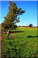
Summerfield Farm From the East
On the Public Footpath to Black Horse Lane. The spindly hawthorn is a leftover from and old hedgeline.
Image: © Mick Garratt
Taken: 10 Sep 2009
0.10 miles
4
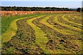
Hay Field, Near Summerfield Farm
Left to dry in the sun.
Image: © Mick Garratt
Taken: 10 Sep 2009
0.23 miles
5
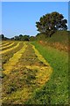
Hay Field, Near Summerfield Farm
Drying in the sun.
Image: © Mick Garratt
Taken: 10 Sep 2009
0.24 miles