IMAGES TAKEN NEAR TO
Staddlebridge, NORTHALLERTON, DL6 3JA
Introduction
This page details the photographs taken nearby to DL6 3JA by members of the Geograph project.
The Geograph project started in 2005 with the aim of publishing, organising and preserving representative images for every square kilometre of Great Britain, Ireland and the Isle of Man.

There are currently over 7.5m images from over14,400 individuals and you can help contribute to the project by visiting https://www.geograph.org.uk
Image Map
Images are licensed for reuse under creativecommons.org/licenses/by-sa/2.0
Notes
- Clicking on the map will re-center to the selected point.
- The higher the marker number, the further away the image location is from the centre of the postcode.
Image Listing (14 Images Found)
Images are licensed for reuse under creativecommons.org/licenses/by-sa/2.0
Image
Details
Distance
2
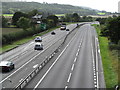
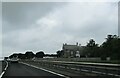
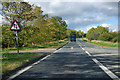
A19 looking south
The view from the A172 overbridge looking south along the A19 dual carriageway. The Cleveland Tontine Inn is visible on the left where the southbound spur of A172 joins A19.
Image: © Gordon Hatton
Taken: 11 Sep 2018
0.08 miles
5
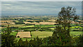
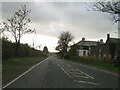
The Cleveland Tontine Inn
A view from Swinestye Hill across the Vale of Mowbray. The Cleveland Tontine Inn, bottom left at the junction of the A19 and A172 is officially the northeasternmost point of the vale which boundary heads arbitrarily in a northeasterly direction to Scotch Corner. To the south is the Vale of Mowbray, to the north the Tees Valley.
The Cleveland Tontine has an interesting history. In the 1980s it was an Egon Ronay standard but expensive restaurant. I remember going there once but wasn’t too impressed when my pigeon soup arrived including a whole bird with its claws sticking up. It dates from 1804 when it was built as a coaching inn. A tontine was the method of raising the funds to finance the build based on a 17th-century Italian concept. Each subscriber pays an agreed sum into the fund, and thereafter receives an annuity based on the annual interest. When an investor dies, his share is reallocated among the surviving investors and this process continues until only one investor survives. Winner takes all so to speak. Each person will only ever receive the interest on his investment, his original fund invested will never be paid back. It is not hard to imagine unscrupulous plotting when only a small group of investors are involved. Quite recently tontine investments have been suggested as a means to fund pensions.
From my photo-diary for 2nd September 2019 see http://www.fhithich.uk/?p=21594
Image: © Mick Garratt
Taken: 2 Sep 2019
0.11 miles
7
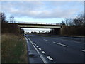
A172 connection from and to northbound A19
Round the bend the connections to the northbound and southbound A19 merge into a single carriageway.
Image: © Robin Webster
Taken: 7 Oct 2011
0.13 miles
8
The Cleveland Tontine from A19 northbound
Image: © Martin Dawes
Taken: 31 Jul 2021
0.14 miles
9
A172 connection from and to northbound A19
It passes over the A19 round the bend.
Image: © Robin Webster
Taken: 7 Oct 2011
0.15 miles
10
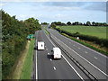
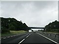
A19 looking north
A view from the A172 overbridge of the A19 dual carriageway heading north. At this junction the A19 leaves the company of the Hambleton and Cleveland Hills which have been visible to the east for some 12 miles or so. From here on the road runs across the Cleveland Plain towards Middlesbrough and Stockton.
Image: © Gordon Hatton
Taken: 11 Sep 2018
0.16 miles