IMAGES TAKEN NEAR TO
Back Parsons Lane, NORTHALLERTON, DL6 3EX
Introduction
This page details the photographs taken nearby to Back Parsons Lane, DL6 3EX by members of the Geograph project.
The Geograph project started in 2005 with the aim of publishing, organising and preserving representative images for every square kilometre of Great Britain, Ireland and the Isle of Man.

There are currently over 7.5m images from over14,400 individuals and you can help contribute to the project by visiting https://www.geograph.org.uk
Image Map
Images are licensed for reuse under creativecommons.org/licenses/by-sa/2.0
Notes
- Clicking on the map will re-center to the selected point.
- The higher the marker number, the further away the image location is from the centre of the postcode.
Image Listing (5 Images Found)
Images are licensed for reuse under creativecommons.org/licenses/by-sa/2.0
Image
Details
Distance
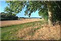
1
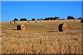
Field Near Beliack Plantation
Taken from just outside the square on the Public Footpath from Black Horse Lane to Fowgill Lane. The houses in the distance are on Parson Back Lane.
Image: © Mick Garratt
Taken: 10 Sep 2009
0.15 miles
2
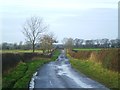
Parson Back Lane
Parson Back Lane leads into Parson's lane, but there's no sign of any parsons or a parsonage.
Image: © Gordon Hatton
Taken: 24 Jan 2014
0.15 miles
5
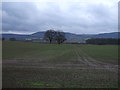
Corner of Beliack Plantation
Taken on the Public Footpath from Black Horse Lane to Fowgill Lane.
Image: © Mick Garratt
Taken: 10 Sep 2009
0.23 miles