IMAGES TAKEN NEAR TO
Long Lane, NORTHALLERTON, DL6 2TG
Introduction
This page details the photographs taken nearby to Long Lane, DL6 2TG by members of the Geograph project.
The Geograph project started in 2005 with the aim of publishing, organising and preserving representative images for every square kilometre of Great Britain, Ireland and the Isle of Man.

There are currently over 7.5m images from over14,400 individuals and you can help contribute to the project by visiting https://www.geograph.org.uk
Image Map (Loading...)


Getting Data...Please wait
Leaflet Map data © OpenStreetMap
Images are licensed for reuse under creativecommons.org/licenses/by-sa/2.0
Notes
- Clicking on the map will re-center to the selected point.
- The higher the marker number, the further away the image location is from the centre of the postcode.
Image Listing (15 Images Found)
Images are licensed for reuse under creativecommons.org/licenses/by-sa/2.0
Image
Details
Distance
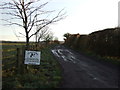
1
Long Lane
On the course of a Roman road.
Image: © Mick Garratt
Taken: 3 Dec 2006
0.02 miles
2

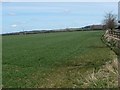
Field Off Long Lane
View east towards Arncliffe.
Image: © Mick Garratt
Taken: 3 Dec 2006
0.02 miles
3

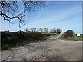
Mount Pleasant Farm
To the west of Long Lane. Only visible because the lane's hedgerow has been cut back.
Image: © Christine Johnstone
Taken: 2 Apr 2015
0.07 miles
4
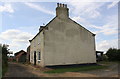
Mount Pleasant farmhouse
Ordnance Survey records indicate that a benchmark levelled at 61.768m above Newlyn Datum was verified in 1959 on an outbuilding at this farm
Image: © Roger Templeman
Taken: 5 Aug 2018
0.08 miles
6
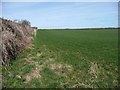
Farmland east of Long Lane, near Low Moor Farm
The hedge borders the lane.
Image: © Christine Johnstone
Taken: 2 Apr 2015
0.10 miles
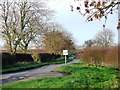
8
59 metre spot height on Long Lane, east of Brompton
Looking north at the entrance to Low Moor. This is a former Roman road.
Image: © Christine Johnstone
Taken: 2 Apr 2015
0.13 miles
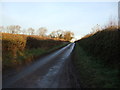
9
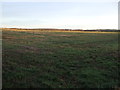
Farmland on the north side of the track to Low Moor
Looking east from Long Lane, about 60 metres above sea level.
Image: © Christine Johnstone
Taken: 2 Apr 2015
0.13 miles