IMAGES TAKEN NEAR TO
Station Road, NORTHALLERTON, DL6 2ST
Introduction
This page details the photographs taken nearby to Station Road, DL6 2ST by members of the Geograph project.
The Geograph project started in 2005 with the aim of publishing, organising and preserving representative images for every square kilometre of Great Britain, Ireland and the Isle of Man.

There are currently over 7.5m images from over14,400 individuals and you can help contribute to the project by visiting https://www.geograph.org.uk
Image Map (Loading...)


Getting Data...Please wait
Leaflet Map data © OpenStreetMap
Images are licensed for reuse under creativecommons.org/licenses/by-sa/2.0
Notes
- Clicking on the map will re-center to the selected point.
- The higher the marker number, the further away the image location is from the centre of the postcode.
Image Listing (57 Images Found)
Images are licensed for reuse under creativecommons.org/licenses/by-sa/2.0
Image
Details
Distance
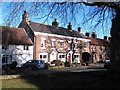
1
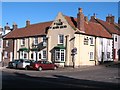
The Three Horse Shoes, Brompton
Pub at the crossroads in the centre of this village.
Image: © Gordon Hatton
Taken: 30 Jan 2010
0.01 miles
2
Lead Lane houses at junction with The Green
There is an OS benchmark Image on the right hand end corner on #2 Lead Lane
Image: © Roger Templeman
Taken: 22 Jul 2012
0.02 miles
3
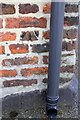
Benchmark on #2 Lead Lane
Ordnance Survey cut mark benchmark described on the Bench Mark Database at http://www.bench-marks.org.uk/bm32902
Image: © Roger Templeman
Taken: 22 Jul 2012
0.02 miles
4
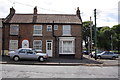
The Crown, Brompton
One of a pair of pubs which face each other across a road in Brompton.
Image: © Gordon Hatton
Taken: 30 Jan 2010
0.03 miles
5
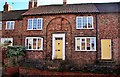
Weavers Cottage, Cockpit Hill, Brompton
An attractive double fronted cottage on Cockpit Hill
Image: © Paul Buckingham
Taken: 16 Feb 2010
0.04 miles
6

Station Road, Brompton
Looking down from the old station end.
Several late 19th / early 20th century buildings.
The stone on the triangular gable end bears the date 1903.
Light industrial use.
Image: © Bob Embleton
Taken: 2 Jul 2010
0.05 miles
7
Chapel House, Brompton
This building looks like a chapel, and a search through old OS maps shows it as a Methodist chapel. Now converted for domestic use.
Image: © Gordon Hatton
Taken: 30 Jan 2010
0.06 miles
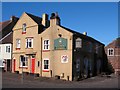
8
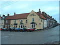
Brompton crossroads
This is one of the two pubs in the middle of Brompton and the road leading off right up over the brow of the hill goes into Water End - Over my left shoulder is the green and the Church
Image: © Nick W
Taken: 3 Dec 2004
0.07 miles
9
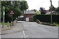
Bow Bridge
Taking Station Road over the Brompton Beck.
Image: © Bob Embleton
Taken: 2 Jul 2010
0.07 miles
10
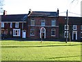
Houses on Church View
Perhaps the most attractive terrace of houses overlooking the green in Brompton. These are late 18thC/early 19thC, and have some nice door cases, although the lower floor windows are a 20thC modification. Listed Grade II - see https://historicengland.org.uk/listing/the-list/list-entry/1190500 for more information.
Image: © Gordon Hatton
Taken: 30 Jan 2010
0.08 miles