IMAGES TAKEN NEAR TO
Deighton, NORTHALLERTON, DL6 2SR
Introduction
This page details the photographs taken nearby to DL6 2SR by members of the Geograph project.
The Geograph project started in 2005 with the aim of publishing, organising and preserving representative images for every square kilometre of Great Britain, Ireland and the Isle of Man.

There are currently over 7.5m images from over14,400 individuals and you can help contribute to the project by visiting https://www.geograph.org.uk
Image Map (Loading...)


Getting Data...Please wait
Leaflet Map data © OpenStreetMap
Images are licensed for reuse under creativecommons.org/licenses/by-sa/2.0
Notes
- Clicking on the map will re-center to the selected point.
- The higher the marker number, the further away the image location is from the centre of the postcode.
Image Listing (2 Images Found)
Images are licensed for reuse under creativecommons.org/licenses/by-sa/2.0
Image
Details
Distance
1
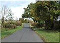
A straight stretch of road towards Appleton Wiske
There are plenty of sharp bends on this minor road, but for a short distance it runs dead straight on the line of an old Roman road that can be traced from near Thirsk to a crossing of the Tees near Middleton One Row.
Image: © Gordon Hatton
Taken: 25 Oct 2020
0.16 miles