IMAGES TAKEN NEAR TO
Deighton, NORTHALLERTON, DL6 2SN
Introduction
This page details the photographs taken nearby to DL6 2SN by members of the Geograph project.
The Geograph project started in 2005 with the aim of publishing, organising and preserving representative images for every square kilometre of Great Britain, Ireland and the Isle of Man.

There are currently over 7.5m images from over14,400 individuals and you can help contribute to the project by visiting https://www.geograph.org.uk
Image Map (Loading...)


Getting Data...Please wait
Leaflet Map data © OpenStreetMap
Images are licensed for reuse under creativecommons.org/licenses/by-sa/2.0
Notes
- Clicking on the map will re-center to the selected point.
- The higher the marker number, the further away the image location is from the centre of the postcode.
Image Listing (14 Images Found)
Images are licensed for reuse under creativecommons.org/licenses/by-sa/2.0
Image
Details
Distance
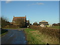
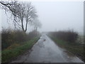
1
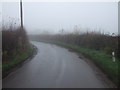
Deighton Lane heading west
Towards the A167.
Image: © JThomas
Taken: 24 Nov 2012
0.08 miles
6

Lane heading west from Deighton
Quiet country lane heading west from Deighton towards the A167 Northallerton to Darlington road.
Image: © Gordon Hatton
Taken: 25 Oct 2020
0.19 miles
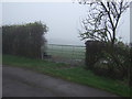
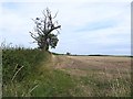
7
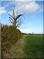
Decayed ash tree in a hedge
This ash looks as though it has been on its last legs for quite some time and is unlikely to have been a victim of ash die back disease. Field edge at Deighton.
Image: © Gordon Hatton
Taken: 25 Oct 2020
0.22 miles
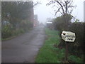
9
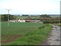
Road to Valley Farm
Farm in the middle of the Vale of Mowbray.
Image: © Gordon Hatton
Taken: 25 Oct 2020
0.23 miles
10
Deighton Lane heading west
Towards the A167.
Image: © JThomas
Taken: 24 Nov 2012
0.23 miles