IMAGES TAKEN NEAR TO
Ellerbeck, NORTHALLERTON, DL6 2RY
Introduction
This page details the photographs taken nearby to DL6 2RY by members of the Geograph project.
The Geograph project started in 2005 with the aim of publishing, organising and preserving representative images for every square kilometre of Great Britain, Ireland and the Isle of Man.

There are currently over 7.5m images from over14,400 individuals and you can help contribute to the project by visiting https://www.geograph.org.uk
Image Map (Loading...)


Getting Data...Please wait
Leaflet Map data © OpenStreetMap
Images are licensed for reuse under creativecommons.org/licenses/by-sa/2.0
Notes
- Clicking on the map will re-center to the selected point.
- The higher the marker number, the further away the image location is from the centre of the postcode.
Image Listing (7 Images Found)
Images are licensed for reuse under creativecommons.org/licenses/by-sa/2.0
Image
Details
Distance
4
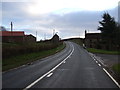
A684 heading east at Ellerbbeck
Towards the A19.
Image: © JThomas
Taken: 15 Dec 2012
0.05 miles
5
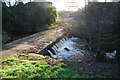
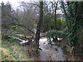
Ford at Ellerbeck
This irish bridge ford on the Cod Beck is found at Village Farm in the centre of Ellerbeck.
Image: © John Walton
Taken: 3 Jan 2014
0.05 miles

7
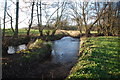
Ford at Ellerbeck
This ford is found on the Cod Beck at Ellerbeck.
Image: © John Walton
Taken: 3 Jan 2014
0.22 miles