IMAGES TAKEN NEAR TO
Mill Hill Drive, NORTHALLERTON, DL6 2QL
Introduction
This page details the photographs taken nearby to Mill Hill Drive, DL6 2QL by members of the Geograph project.
The Geograph project started in 2005 with the aim of publishing, organising and preserving representative images for every square kilometre of Great Britain, Ireland and the Isle of Man.

There are currently over 7.5m images from over14,400 individuals and you can help contribute to the project by visiting https://www.geograph.org.uk
Image Map (Loading...)


Getting Data...Please wait
Leaflet Map data © OpenStreetMap
Images are licensed for reuse under creativecommons.org/licenses/by-sa/2.0
Notes
- Clicking on the map will re-center to the selected point.
- The higher the marker number, the further away the image location is from the centre of the postcode.
Image Listing (33 Images Found)
Images are licensed for reuse under creativecommons.org/licenses/by-sa/2.0
Image
Details
Distance
1
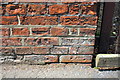
Benchmark on building on Northallerton Road
Ordnance Survey cut mark benchmark described on the Bench Mark Database at http://www.bench-marks.org.uk/bm32898
Image: © Roger Templeman
Taken: 22 Jul 2012
0.06 miles
2
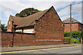
Building on Northallerton Road
There is an OS benchmark Image on the roadside face of the building near the far end
Image: © Roger Templeman
Taken: 22 Jul 2012
0.07 miles
3

Brompton Convenience Stores
One village shop selling a huge variety of items.
Looking down the Northallerton Road from near the High Green by the churchyard.
Image: © Bob Embleton
Taken: 2 Jul 2010
0.11 miles
4
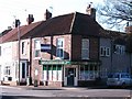
Village shop, Brompton
Brompton Convenience Store stands on a corner close to the church and green.
Image: © Gordon Hatton
Taken: 30 Jan 2010
0.12 miles
5
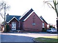
Brompton Methodist Church
Just 150m or so from the original chapel, the Methodist church makes use of old Sunday school buildings.
Image: © Gordon Hatton
Taken: 30 Jan 2010
0.12 miles
6
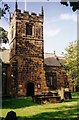
St Thomas' Church, Brompton by Northallerton
Looking towards the main door on the south side of the tower.
Image: © Rich Tea
Taken: Unknown
0.13 miles
7
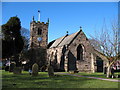
St Thomas' Church, Brompton by Northallerton
The gravestones in the left foreground are mainly those of my Stainthorp ancestors.
Image: © Rich Tea
Taken: 2 Mar 2004
0.14 miles
8
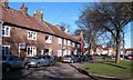
A corner of the green
Brompton is a village with two greens, that in the village centre is known as High Green and is irregular in shape with some infill. This is the southern corner, lined by modest brick and pantile cottages.
Image: © Gordon Hatton
Taken: 30 Jan 2010
0.14 miles
9

Postbox, High Green, Brompton
George V postbox by the churchyard wall.
Behind is St Thomas' Church
Image: © Bob Embleton
Taken: 2 Jul 2010
0.15 miles
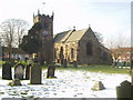
10
St Thomas's Church, Brompton
The village church stands at one end of the green. It dates back to the 12thC, but was heavily restored in the 1860's. Notable for its collection of hogs back tombs.
Image: © Gordon Hatton
Taken: 30 Jan 2010
0.15 miles