IMAGES TAKEN NEAR TO
Northallerton Road, NORTHALLERTON, DL6 2PZ
Introduction
This page details the photographs taken nearby to Northallerton Road, DL6 2PZ by members of the Geograph project.
The Geograph project started in 2005 with the aim of publishing, organising and preserving representative images for every square kilometre of Great Britain, Ireland and the Isle of Man.

There are currently over 7.5m images from over14,400 individuals and you can help contribute to the project by visiting https://www.geograph.org.uk
Image Map (Loading...)


Getting Data...Please wait
Leaflet Map data © OpenStreetMap
Images are licensed for reuse under creativecommons.org/licenses/by-sa/2.0
Notes
- Clicking on the map will re-center to the selected point.
- The higher the marker number, the further away the image location is from the centre of the postcode.
Image Listing (15 Images Found)
Images are licensed for reuse under creativecommons.org/licenses/by-sa/2.0
Image
Details
Distance
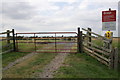
1
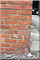
Benchmark on barn at Halfway House
Ordnance Survey cut mark benchmark described on the Bench Mark Database at http://www.bench-marks.org.uk/bm32864
Image: © Roger Templeman
Taken: 12 Aug 2012
0.02 miles
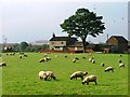
2
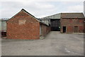
Farm buildings at Halfway House
There is an OS benchmark Image on the front right corner of the near barn
Image: © Roger Templeman
Taken: 12 Aug 2012
0.02 miles
3
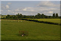
Fields between Brompton and Northallerton
Image: © Christopher Hilton
Taken: 12 Jul 2015
0.05 miles
4
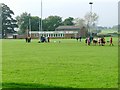
Northallerton RUFC Pavilion
The easting bisects the pitch.
Image: © Mick Garratt
Taken: 16 Oct 2005
0.06 miles
5
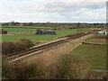
The line to Middlesbrough
The railway line on the north side of Northallerton as seen from the new relief road, B6271.
Image: © Gordon Hatton
Taken: 13 Jan 2023
0.06 miles

9
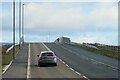
The long awaited bridge is open
The bridge crosses both the railway line and North Beck, and although construction appears to have been completed many months ago, the bridge, which carries the B6271 relief road has only recently opened to traffic. The new road connects the A167 to the A684 on the north side of the town and should offer an alternative route into the town centre for motorists hoping to avoid a long wait at the level crossing on the A167 direct route, but does one come this long way round or take a chance that the notorious level crossing will be open?
Image: © Gordon Hatton
Taken: 13 Jan 2023
0.12 miles
10
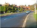
Northallerton Road, Brompton
View north
Image: © Mick Garratt
Taken: 19 Nov 2005
0.13 miles