IMAGES TAKEN NEAR TO
Hutton Bonville, NORTHALLERTON, DL6 2PP
Introduction
This page details the photographs taken nearby to DL6 2PP by members of the Geograph project.
The Geograph project started in 2005 with the aim of publishing, organising and preserving representative images for every square kilometre of Great Britain, Ireland and the Isle of Man.

There are currently over 7.5m images from over14,400 individuals and you can help contribute to the project by visiting https://www.geograph.org.uk
Image Map (Loading...)


Getting Data...Please wait
Leaflet Map data © OpenStreetMap
Images are licensed for reuse under creativecommons.org/licenses/by-sa/2.0
Notes
- Clicking on the map will re-center to the selected point.
- The higher the marker number, the further away the image location is from the centre of the postcode.
Image Listing (2 Images Found)
Images are licensed for reuse under creativecommons.org/licenses/by-sa/2.0
Image
Details
Distance
1
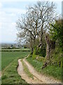
Track to Fox Covert Farm
Track and public footpath heading west from Lovesome Hill.
Image: © Gordon Hatton
Taken: 25 Apr 2021
0.17 miles
2
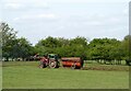
Muck spreading, Lovesome Hill
Steadily going around the field flinging out lumps of cow dung. Nearby track under threat from flying muck as the tractor turns the other way!
Image: © Gordon Hatton
Taken: 25 Apr 2021
0.23 miles