IMAGES TAKEN NEAR TO
Brompton, NORTHALLERTON, DL6 2PF
Introduction
This page details the photographs taken nearby to DL6 2PF by members of the Geograph project.
The Geograph project started in 2005 with the aim of publishing, organising and preserving representative images for every square kilometre of Great Britain, Ireland and the Isle of Man.

There are currently over 7.5m images from over14,400 individuals and you can help contribute to the project by visiting https://www.geograph.org.uk
Image Map (Loading...)


Getting Data...Please wait
Leaflet Map data © OpenStreetMap
Images are licensed for reuse under creativecommons.org/licenses/by-sa/2.0
Notes
- Clicking on the map will re-center to the selected point.
- The higher the marker number, the further away the image location is from the centre of the postcode.
Image Listing (14 Images Found)
Images are licensed for reuse under creativecommons.org/licenses/by-sa/2.0
Image
Details
Distance
1
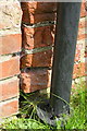
Benchmark on Mill House, Rose Cottage Farm
Ordnance Survey cut mark benchmark described on the Bench Mark Database at http://www.bench-marks.org.uk/bm32897
Image: © Roger Templeman
Taken: 22 Jul 2012
0.02 miles
2
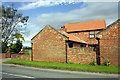
Mill House, Rose Cottage Farm, Brompton Lane
There is an OS benchmark Image behind the downpipe on the left hand end of the building
Image: © Roger Templeman
Taken: 22 Jul 2012
0.03 miles
4
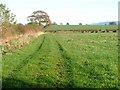
Track to Firtree Farm from Brompton Lane
Image: © Roger Templeman
Taken: 22 Jul 2012
0.13 miles
5
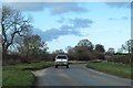
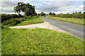
Brompton Lane
A well used unclassified road linking Brompton with the A167 at Oaktree Hill. The road cuts through the SW corner of the square.
Image: © Gordon Hatton
Taken: 4 Mar 2019
0.14 miles
6
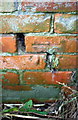
Benchmark on old barn at Firtree Farm
Ordnance Survey cut mark benchmark described on the Bench Mark Database at http://www.bench-marks.org.uk/bm32866
Image: © Roger Templeman
Taken: 23 Jul 2017
0.17 miles
7
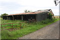
Old barns beside track to Firtree Farm
There is an OS benchmark Image on the track face of the far barn at the junction with the near building
Image: © Roger Templeman
Taken: 23 Jul 2017
0.17 miles
8
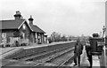
Brompton (North Yorks.) Station
View NE, towards Eaglescliffe; ex-North Eastern, Northallerton - Eaglescliffe - Stockton/Middlesbrough etc. main line. The station was closed 8/9/65, but the line is of course still a major artery. (That is NOT my Dad!)
Image: © Ben Brooksbank
Taken: 19 Apr 1961
0.21 miles
9

Station Road level crossing
There used to be a station house on the far side of the railway on the right hand side of the road Image Nothing remains of it now. See http://www.bench-marks.org.uk/bm32900
Image: © Roger Templeman
Taken: 22 Jul 2012
0.22 miles
10
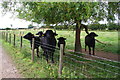
Buffalo in field beside track to Firtree Farm
Image: © Roger Templeman
Taken: 23 Jul 2017
0.22 miles