IMAGES TAKEN NEAR TO
Stone Cross, Rotary Way, NORTHALLERTON, DL6 2FF
Introduction
This page details the photographs taken nearby to Stone Cross, Rotary Way, DL6 2FF by members of the Geograph project.
The Geograph project started in 2005 with the aim of publishing, organising and preserving representative images for every square kilometre of Great Britain, Ireland and the Isle of Man.

There are currently over 7.5m images from over14,400 individuals and you can help contribute to the project by visiting https://www.geograph.org.uk
Image Map
Images are licensed for reuse under creativecommons.org/licenses/by-sa/2.0
Notes
- Clicking on the map will re-center to the selected point.
- The higher the marker number, the further away the image location is from the centre of the postcode.
Image Listing (19 Images Found)
Images are licensed for reuse under creativecommons.org/licenses/by-sa/2.0
Image
Details
Distance
1
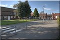
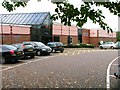
Allertonshire School
A comprehensive school for 11 - 14 year olds and designated as a specialist technology college.
Image: © Mick Garratt
Taken: 4 Oct 2009
0.01 miles
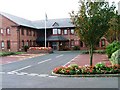
4
Hambleton Leisure Centre, Northallerton
Image: © Mick Garratt
Taken: 16 Oct 2005
0.07 miles
5
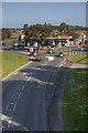
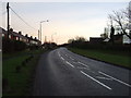
A684
Taken from the top of the footbridge. Brompton Road on the right.
Image: © Mick Garratt
Taken: 4 Oct 2009
0.10 miles

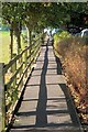
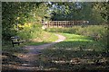
7
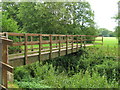
North Beck Footbridge
Part of Northallerton recreation ground can be seen between the trees.
Image: © David Rogers
Taken: 20 Jul 2010
0.10 miles
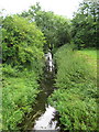
9
Seat Overlooking North Beck
A bridge over the beck is in the distance.
Image: © Mick Garratt
Taken: 4 Oct 2009
0.12 miles