IMAGES TAKEN NEAR TO
Appleton Wiske, NORTHALLERTON, DL6 2AY
Introduction
This page details the photographs taken nearby to DL6 2AY by members of the Geograph project.
The Geograph project started in 2005 with the aim of publishing, organising and preserving representative images for every square kilometre of Great Britain, Ireland and the Isle of Man.

There are currently over 7.5m images from over14,400 individuals and you can help contribute to the project by visiting https://www.geograph.org.uk
Image Map (Loading...)


Getting Data...Please wait
Leaflet Map data © OpenStreetMap
Images are licensed for reuse under creativecommons.org/licenses/by-sa/2.0
Notes
- Clicking on the map will re-center to the selected point.
- The higher the marker number, the further away the image location is from the centre of the postcode.
Image Listing (4 Images Found)
Images are licensed for reuse under creativecommons.org/licenses/by-sa/2.0
Image
Details
Distance
1
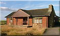
Rose Acre
A strange building, I thought it was a sports pavilion at first. Barricaded up and hidden behind a high wire fence and becoming dilapidated.
Image: © Mick Garratt
Taken: 6 Jul 2006
0.05 miles