IMAGES TAKEN NEAR TO
Fountains Place, NORTHALLERTON, DL6 1QS
Introduction
This page details the photographs taken nearby to Fountains Place, DL6 1QS by members of the Geograph project.
The Geograph project started in 2005 with the aim of publishing, organising and preserving representative images for every square kilometre of Great Britain, Ireland and the Isle of Man.

There are currently over 7.5m images from over14,400 individuals and you can help contribute to the project by visiting https://www.geograph.org.uk
Image Map
Images are licensed for reuse under creativecommons.org/licenses/by-sa/2.0
Notes
- Clicking on the map will re-center to the selected point.
- The higher the marker number, the further away the image location is from the centre of the postcode.
Image Listing (4 Images Found)
Images are licensed for reuse under creativecommons.org/licenses/by-sa/2.0
Image
Details
Distance
1

Allertonshire School
A comprehensive school for 11 - 14 year olds built in the late 1950s and now designated as a specialist technology college. Compare with Image
Image: © Mick Garratt
Taken: 4 Oct 2009
0.20 miles
2
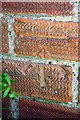
Benchmark on #35A Turker Close
Ordnance Survey cut mark benchmark described on the Bench Mark Database at http://www.bench-marks.org.uk/bm43109
Image: © Roger Templeman
Taken: 27 May 2012
0.21 miles
3
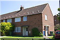
Houses of Turker Close
There is an OS benchmark Image on the front corner of the nearest house, behind the low bush
Image: © Roger Templeman
Taken: 27 May 2012
0.22 miles
4
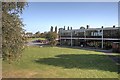
Allertonshire School
A comprehensive school for 11 - 14 year olds built in the late 1950s and now designated as a specialist technology college. Compare with Image
Image: © Mick Garratt
Taken: 4 Oct 2009
0.22 miles