IMAGES TAKEN NEAR TO
Priory Close, NORTHALLERTON, DL6 1LN
Introduction
This page details the photographs taken nearby to Priory Close, DL6 1LN by members of the Geograph project.
The Geograph project started in 2005 with the aim of publishing, organising and preserving representative images for every square kilometre of Great Britain, Ireland and the Isle of Man.

There are currently over 7.5m images from over14,400 individuals and you can help contribute to the project by visiting https://www.geograph.org.uk
Image Map (Loading...)


Getting Data...Please wait
Leaflet Map data © OpenStreetMap
Images are licensed for reuse under creativecommons.org/licenses/by-sa/2.0
Notes
- Clicking on the map will re-center to the selected point.
- The higher the marker number, the further away the image location is from the centre of the postcode.
Image Listing (195 Images Found)
Images are licensed for reuse under creativecommons.org/licenses/by-sa/2.0
Image
Details
Distance
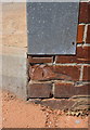
3
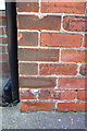
Benchmark on #5 Brompton Road
Ordnance Survey cut mark benchmark described on the Bench Mark Database at http://www.bench-marks.org.uk/bm32860
Image: © Roger Templeman
Taken: 27 May 2012
0.06 miles
4
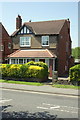
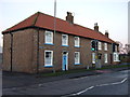
#5 Brompton Road
There is an OS benchmark Image on the front side corner of the house
Image: © Roger Templeman
Taken: 27 May 2012
0.06 miles
5
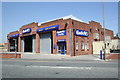
Kwik Fit garage, Brompton Road
The building was formerly a bus station. There is an OS benchmark Image on the front side corner of the building below the metal strip.
Image: © Roger Templeman
Taken: 27 May 2012
0.07 miles
6
Benchmark on the Old Bus Station, Brompton Road
Ordnance Survey cut mark benchmark described on the Bench Mark Database at http://www.bench-marks.org.uk/bm32862
Image: © Roger Templeman
Taken: 27 May 2012
0.08 miles
7
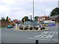
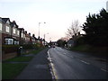
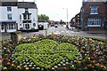
Northallerton - Roundabout at Brompton Road (south end)
Roundabout with Friarage Street to the left, Brompton Road ahead, and East Road on the right. The flower tubs are neat and very effective. A nice touch.
Image: © David Ward
Taken: 27 Jul 2007
0.08 miles
9
Friarage Street
Viewed from the floral roundabout celebrating the centenary of The Scouts. Friarage Street is quite short leading towards the Friarage Hospital which built on the 14th century religious house built by the Carmelite Friars. The bollards along the wide pavement indicate the edge of the now enclosed Sun Beck much enjoyed by adventurous children (and one in particular around 1960 !).
Image: © Bob Embleton
Taken: 20 Jun 2007
0.12 miles
10
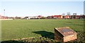
Forest Road Playing Fields and Former Swimming Pool Site
Here stood the Memorial Swimming Baths - built by public subscription in 1961. I remember door to door collections to raise the funds. Here I learnt to swim in 1964. It was used by the schools, The Police, RAF Leeming and the general Public.
The plaque saved from the demolition reads :
"These baths are erected in grateful remembrance of those who laid down their lives that others might live in freedom. Their name liveth for evermore. June 1961."
A smaller plaque explains :
"This plaque and bricks in this plinth were recovered from the memorial bath demolished in January 1995. The plaque was rededicated on the anniversary of V.E. Day 8th May 1995"
Image: © Bob Embleton
Taken: 16 Dec 2006
0.12 miles