IMAGES TAKEN NEAR TO
Bullamoor Road, NORTHALLERTON, DL6 1JW
Introduction
This page details the photographs taken nearby to Bullamoor Road, DL6 1JW by members of the Geograph project.
The Geograph project started in 2005 with the aim of publishing, organising and preserving representative images for every square kilometre of Great Britain, Ireland and the Isle of Man.

There are currently over 7.5m images from over14,400 individuals and you can help contribute to the project by visiting https://www.geograph.org.uk
Image Map (Loading...)


Getting Data...Please wait
Leaflet Map data © OpenStreetMap
Images are licensed for reuse under creativecommons.org/licenses/by-sa/2.0
Notes
- Clicking on the map will re-center to the selected point.
- The higher the marker number, the further away the image location is from the centre of the postcode.
Image Listing (34 Images Found)
Images are licensed for reuse under creativecommons.org/licenses/by-sa/2.0
Image
Details
Distance
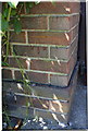
1
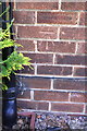
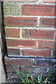
Benchmark on #57 Bullamoor Road
Ordnance Survey cut mark benchmark described on the Bench Mark Database at http://www.bench-marks.org.uk/bm43204
Image: © Roger Templeman
Taken: 27 May 2012
0.03 miles
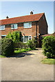
2
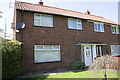
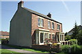
#57 Bullamoor Road
There is an OS benchmark Image on the front left corner of the house
Image: © Roger Templeman
Taken: 27 May 2012
0.03 miles
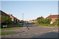
3
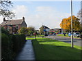
Bullamoor Road, Northallerton
Looking westward.
Image: © Peter Wood
Taken: 17 Oct 2014
0.04 miles
4
Elm Avenue
Part of the 1950s council housing explosion. Elm avenue connects The Crescent to Bullamoor Road
Image: © Bob Embleton
Taken: 29 Oct 2008
0.07 miles
5
Benchmark on #83 Bullamoor Road
Ordnance Survey cut mark benchmark described on the Bench Mark Database at http://www.bench-marks.org.uk/bm43203
Image: © Roger Templeman
Taken: 27 May 2012
0.07 miles
6
#83 Bullamoor Road
There is an OS benchmark Image on the front corner of the house
Image: © Roger Templeman
Taken: 27 May 2012
0.07 miles
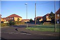
7
The Crescent
The outer of two concentric roads of 1950s council houses ending on Valley Road.
Image: © Bob Embleton
Taken: 20 Jun 2007
0.08 miles
8
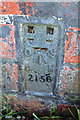
Benchmark on #1 Eastbrook, Bullamoor Road
Ordnance Survey flush bracket serial number 2156 benchmark described on the Bench Mark Database at http://www.bench-marks.org.uk/bm10193
Image: © Roger Templeman
Taken: 27 May 2012
0.09 miles
9
Houses of Eastbrook, Bullamoor Road
The near house has an OS benchmark Image on the bricks left exposed below the pebbledash
Image: © Roger Templeman
Taken: 27 May 2012
0.10 miles
10
Benchmark on #20 Turker Close
Ordnance Survey cut mark benchmark described on the Bench Mark Database at http://www.bench-marks.org.uk/bm43202
Image: © Roger Templeman
Taken: 27 May 2012
0.12 miles