IMAGES TAKEN NEAR TO
Bankhead Road, NORTHALLERTON, DL6 1JD
Introduction
This page details the photographs taken nearby to Bankhead Road, DL6 1JD by members of the Geograph project.
The Geograph project started in 2005 with the aim of publishing, organising and preserving representative images for every square kilometre of Great Britain, Ireland and the Isle of Man.

There are currently over 7.5m images from over14,400 individuals and you can help contribute to the project by visiting https://www.geograph.org.uk
Image Map
Images are licensed for reuse under creativecommons.org/licenses/by-sa/2.0
Notes
- Clicking on the map will re-center to the selected point.
- The higher the marker number, the further away the image location is from the centre of the postcode.
Image Listing (9 Images Found)
Images are licensed for reuse under creativecommons.org/licenses/by-sa/2.0
Image
Details
Distance
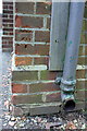
1
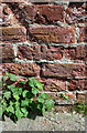
Benchmark on outbuilding at Prospect House
Ordnance Survey cut mark benchmark described on the Bench Mark Database at http://www.bench-marks.org.uk/bm87435
Image: © Roger Templeman
Taken: 13 Aug 2017
0.18 miles
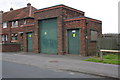
2
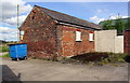
Outbuilding at Prospect House
There is an OS benchmark Image at the centre of building's near end face, right of the large blue wheelie bin
Image: © Roger Templeman
Taken: 13 Aug 2017
0.18 miles
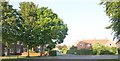
3
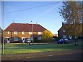
Short Terraced Houses, The Crescent
Part of the 1950s post-war expansion of the council houses. Here three homes are attached. The planners had little concept of future car ownership. The small green provides a useful open space - enjoyed by all - especially the young.
Image: © Bob Embleton
Taken: 29 Oct 2008
0.21 miles
4
Electricity substation on Greenhowsyke Lane
There is an OS benchmark Image on the near side of the substation to the left of the grey downpipe
Image: © Roger Templeman
Taken: 15 Jul 2012
0.24 miles
5
Benchmark on electricity substation, Greenhowsyke Lane
Ordnance Survey cut mark benchmark described on the Bench Mark Database at http://www.bench-marks.org.uk/bm44002
Image: © Roger Templeman
Taken: 15 Jul 2012
0.24 miles
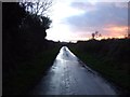
7
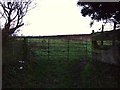
Along Scholla Lane
The road climbs from Northallerton up the hill.
Image: © DS Pugh
Taken: 29 May 2016
0.24 miles
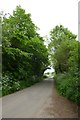
8
Central Drive
The inner of two concentric roads of 1950s council houses, built before many people needed garages.
Image: © Bob Embleton
Taken: 20 Jun 2007
0.25 miles