IMAGES TAKEN NEAR TO
Brompton Road, NORTHALLERTON, DL6 1DY
Introduction
This page details the photographs taken nearby to Brompton Road, DL6 1DY by members of the Geograph project.
The Geograph project started in 2005 with the aim of publishing, organising and preserving representative images for every square kilometre of Great Britain, Ireland and the Isle of Man.

There are currently over 7.5m images from over14,400 individuals and you can help contribute to the project by visiting https://www.geograph.org.uk
Image Map
Images are licensed for reuse under creativecommons.org/licenses/by-sa/2.0
Notes
- Clicking on the map will re-center to the selected point.
- The higher the marker number, the further away the image location is from the centre of the postcode.
Image Listing (148 Images Found)
Images are licensed for reuse under creativecommons.org/licenses/by-sa/2.0
Image
Details
Distance
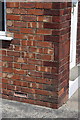
1
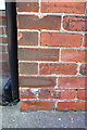
Benchmark on #5 Brompton Road
Ordnance Survey cut mark benchmark described on the Bench Mark Database at http://www.bench-marks.org.uk/bm32860
Image: © Roger Templeman
Taken: 27 May 2012
0.04 miles
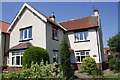
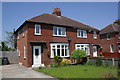
2
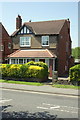
#5 Brompton Road
There is an OS benchmark Image on the front side corner of the house
Image: © Roger Templeman
Taken: 27 May 2012
0.04 miles
4
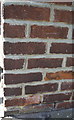
Benchmark on #27 Brompton Road
Ordnance Survey cut mark benchmark described on the Bench Mark Database at http://www.bench-marks.org.uk/bm32861
Image: © Roger Templeman
Taken: 27 May 2012
0.08 miles
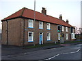
5
#27 Brompton Road, 'Holmfield'
There is an OS benchmark Image on the east angle of the house
Image: © Roger Templeman
Taken: 27 May 2012
0.08 miles
7
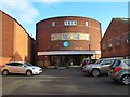
Church or cinema?
This was once a cinema just off Northallerton's High Street, but now it is the New Life Baptist Church.
Image: © Gordon Hatton
Taken: 30 Jan 2024
0.12 miles
8
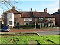
Porch House, High Street
This interesting building stands across the road from the parish church and has origins in the late 16th century, but with many alterations and additions through the 17th, 18th and 19th centuries. The projecting wing to the left is of 1780, whilst the main building with its pantile roof was once thatched. Tradition has it that King Charles I stayed here on two occasions, in 1640 and 1647. The building is Grade II listed.
Image: © Gordon Hatton
Taken: 30 Jan 2024
0.13 miles
9
Benchmark on #17 Quaker Lane
Ordnance Survey cut mark benchmark described on the Bench Mark Database at http://www.bench-marks.org.uk/bm32857
Image: © Roger Templeman
Taken: 27 May 2012
0.13 miles
10
#17 Quaker Lane
There is an OS benchmark Image on the side front corner of the house
Image: © Roger Templeman
Taken: 27 May 2012
0.13 miles