IMAGES TAKEN NEAR TO
Sampson Place, NEWTON AYCLIFFE, DL5 7NX
Introduction
This page details the photographs taken nearby to Sampson Place, DL5 7NX by members of the Geograph project.
The Geograph project started in 2005 with the aim of publishing, organising and preserving representative images for every square kilometre of Great Britain, Ireland and the Isle of Man.

There are currently over 7.5m images from over14,400 individuals and you can help contribute to the project by visiting https://www.geograph.org.uk
Image Map
Images are licensed for reuse under creativecommons.org/licenses/by-sa/2.0
Notes
- Clicking on the map will re-center to the selected point.
- The higher the marker number, the further away the image location is from the centre of the postcode.
Image Listing (7 Images Found)
Images are licensed for reuse under creativecommons.org/licenses/by-sa/2.0
Image
Details
Distance
3
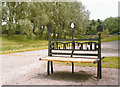
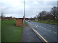
Seating on the Great Aycliffe Way Newton Aycliffe
Image: © Peter Robinson
Taken: 20 Jun 1998
0.17 miles
4
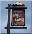
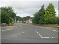
Sign for the Cobblers Hall, Newton Aycliffe
Image: © JThomas
Taken: 28 Nov 2015
0.22 miles
5
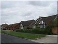
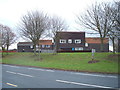
Detached bungalows in Westmorland Way at Newton Aycliffe
Left to right odd numbers 21 to 29
Image: © Peter Robinson
Taken: 24 Apr 2012
0.23 miles
7
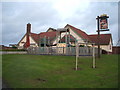
The Cobblers Hall public house, Newton Aycliffe
On Burnhill Way.
Image: © JThomas
Taken: 28 Nov 2015
0.24 miles