IMAGES TAKEN NEAR TO
Arncliffe Place, NEWTON AYCLIFFE, DL5 7EE
Introduction
This page details the photographs taken nearby to Arncliffe Place, DL5 7EE by members of the Geograph project.
The Geograph project started in 2005 with the aim of publishing, organising and preserving representative images for every square kilometre of Great Britain, Ireland and the Isle of Man.

There are currently over 7.5m images from over14,400 individuals and you can help contribute to the project by visiting https://www.geograph.org.uk
Image Map
Images are licensed for reuse under creativecommons.org/licenses/by-sa/2.0
Notes
- Clicking on the map will re-center to the selected point.
- The higher the marker number, the further away the image location is from the centre of the postcode.
Image Listing (4 Images Found)
Images are licensed for reuse under creativecommons.org/licenses/by-sa/2.0
Image
Details
Distance
1
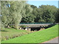
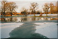
Stephenson Way road bridge Newton Aycliffe
Bridging Woodham Burn in this County Durham town
Image: © Peter Robinson
Taken: 20 Sep 2009
0.13 miles
2

Stephenson Way Cemetery, Newton Aycliffe
Stephenson Way Cemetery in Newton Aycliffe is an unusual burial place. It appears that most, if not all gravestones are small and are laid on the ground; none seem to be erect. The overall impression is one of untidiness and that extends to the graves themselves where a good number have 'trinket-like' adornments in addition to flowers. At the time the image was recorded, end of January 2016, many of those were Christmas decorations - more than a month after the event.
Image: © Trevor Littlewood
Taken: 30 Jan 2016
0.17 miles
3
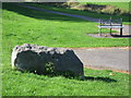
Dolerite erratic Newton Aycliffe
In West Park Newton Aycliffe County Durham
Image: © Peter Robinson
Taken: 20 Sep 2009
0.17 miles