IMAGES TAKEN NEAR TO
Honister Place, NEWTON AYCLIFFE, DL5 7DL
Introduction
This page details the photographs taken nearby to Honister Place, DL5 7DL by members of the Geograph project.
The Geograph project started in 2005 with the aim of publishing, organising and preserving representative images for every square kilometre of Great Britain, Ireland and the Isle of Man.

There are currently over 7.5m images from over14,400 individuals and you can help contribute to the project by visiting https://www.geograph.org.uk
Image Map (Loading...)


Getting Data...Please wait
Leaflet Map data © OpenStreetMap
Images are licensed for reuse under creativecommons.org/licenses/by-sa/2.0
Notes
- Clicking on the map will re-center to the selected point.
- The higher the marker number, the further away the image location is from the centre of the postcode.
Image Listing (7 Images Found)
Images are licensed for reuse under creativecommons.org/licenses/by-sa/2.0
Image
Details
Distance
1
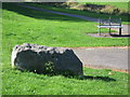
Dolerite erratic Newton Aycliffe
In West Park Newton Aycliffe County Durham
Image: © Peter Robinson
Taken: 20 Sep 2009
0.11 miles
3
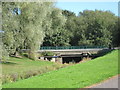
Stephenson Way road bridge Newton Aycliffe
Bridging Woodham Burn in this County Durham town
Image: © Peter Robinson
Taken: 20 Sep 2009
0.15 miles
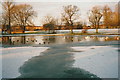
4
Boating Lakes, Newton Aycliffe
The Boating Lakes situated at the West Park Newton Aycliffe
Image: © Neil Atterby
Taken: 15 Jun 2005
0.15 miles
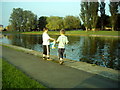
5
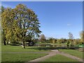
West Park, Newton Aycliffe
Parkland area with large man made lake in Newton Aycliffe.
Image: © David Robinson
Taken: 20 Apr 2024
0.18 miles
6
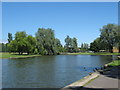
Park Lake
West Park Lake Newton Aycliffe County Durham
Image: © Peter Robinson
Taken: 24 Jun 2009
0.19 miles
7
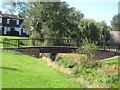
Footbridge over Woodham Burn Newton Aycliffe
Connecting Whinlatter Place with Linden Place in this County Durham New Town
Image: © Peter Robinson
Taken: 20 Sep 2009
0.24 miles