IMAGES TAKEN NEAR TO
Cumbie Way, NEWTON AYCLIFFE, DL5 6YA
Introduction
This page details the photographs taken nearby to Cumbie Way, DL5 6YA by members of the Geograph project.
The Geograph project started in 2005 with the aim of publishing, organising and preserving representative images for every square kilometre of Great Britain, Ireland and the Isle of Man.

There are currently over 7.5m images from over14,400 individuals and you can help contribute to the project by visiting https://www.geograph.org.uk
Image Map
Images are licensed for reuse under creativecommons.org/licenses/by-sa/2.0
Notes
- Clicking on the map will re-center to the selected point.
- The higher the marker number, the further away the image location is from the centre of the postcode.
Image Listing (5 Images Found)
Images are licensed for reuse under creativecommons.org/licenses/by-sa/2.0
Image
Details
Distance
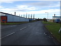
1
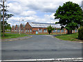
Former WW2 Royal Ordnance Factory building
Now occupied by timber merchants,one of the few original buildings remaining. Situated in Aycliffe Industrial Estate Newton Aycliffe County Durham.
Image: © Peter Robinson
Taken: 9 Jul 2009
0.14 miles
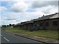
2
Heighington Lane
The B6444 east of Heighington railway station.
Image: © Thomas Nugent
Taken: 3 Jun 2017
0.23 miles
3
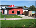
Little Cubs nursery at Newton Aycliffe Excel Centre
Image: © Peter Robinson
Taken: 31 Aug 2010
0.23 miles
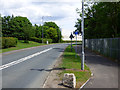
4
Station Road
Off the B6444 Heighington Lane, near Heighington railway station.
Image: © Thomas Nugent
Taken: 3 Jun 2017
0.25 miles