IMAGES TAKEN NEAR TO
Northfield Way, NEWTON AYCLIFFE, DL5 6UF
Introduction
This page details the photographs taken nearby to Northfield Way, DL5 6UF by members of the Geograph project.
The Geograph project started in 2005 with the aim of publishing, organising and preserving representative images for every square kilometre of Great Britain, Ireland and the Isle of Man.

There are currently over 7.5m images from over14,400 individuals and you can help contribute to the project by visiting https://www.geograph.org.uk
Image Map (Loading...)


Getting Data...Please wait
Leaflet Map data © OpenStreetMap
Images are licensed for reuse under creativecommons.org/licenses/by-sa/2.0
Notes
- Clicking on the map will re-center to the selected point.
- The higher the marker number, the further away the image location is from the centre of the postcode.
Image Listing (10 Images Found)
Images are licensed for reuse under creativecommons.org/licenses/by-sa/2.0
Image
Details
Distance
1
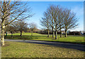
Trees and grass - landscaping at Newton Aycliffe Industrial Estate
Modern industrial estates see much more landscaping and greenery than those of the past; the Newton Aycliffe estate is a good example.
Image: © Trevor Littlewood
Taken: 8 Feb 2015
0.10 miles
2
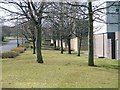
Newton Aycliffe Industrial Estate
Northfield Way
Image: © Mick Garratt
Taken: 14 Apr 2006
0.11 miles
3

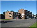
27b Watson Road in Newton Aycliffe County Durham
A semi-detached dwelling, one of a number of infill properties built after most of the B2 precinct was constructed in the early 1950's
Image: © Peter Robinson
Taken: 19 Aug 1993
0.13 miles
4
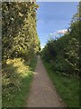
Footpath On Former Railway Line
The footpath uses the course of the railway that ran from Shildon - Middlesbrough, transporting coal traffic in enough volume for it to be electrified between 1915 and 1935. Armament factories were also positioned nearby during WWII. Trains between Shildon and Teesside now travel via Darlington.
Image: © David Robinson
Taken: 20 Sep 2021
0.16 miles
5

Playday children's nursery
Situated in the old part of Newton Aycliffe next to the disused steam railway line and old crossing.
Image: © tony jary
Taken: 28 May 2006
0.19 miles
6
Simpasture Gate shops Newton Aycliffe
Built in the early 50's during the development of this County Durham New Town
Image: © Peter Robinson
Taken: 20 Sep 2009
0.21 miles
7
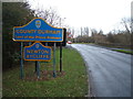
Entering Newton Aycliffe (County Durham)
Heading east on School Aycliffe Lane.
Image: © JThomas
Taken: 28 Nov 2015
0.22 miles
8
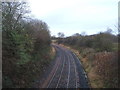
Railway towards Bishop Auckland
Looking north from the bridge on School Aycliffe Lane.
Image: © JThomas
Taken: 28 Nov 2015
0.22 miles
9
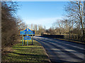
Two blue and yellow road signs
As the road signs indicate the minor road is entering both Newton Aycliffe and County Durham (from the area of Darlington Unitary Authority). The low wall on the right side of the road is a parapet of a bridge over a railway route. The road signs are in a style in use in County Durham for some time.
Image: © Trevor Littlewood
Taken: 8 Feb 2015
0.22 miles
10
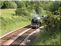
Railway Tracks at Newton Aycliffe
The Tornado A1Paciffic class on its way to the Railway Museum at Shildon.
Image: © malcolm tebbit
Taken: 23 Jun 2010
0.24 miles