IMAGES TAKEN NEAR TO
Haselrigg Close, NEWTON AYCLIFFE, DL5 6QT
Introduction
This page details the photographs taken nearby to Haselrigg Close, DL5 6QT by members of the Geograph project.
The Geograph project started in 2005 with the aim of publishing, organising and preserving representative images for every square kilometre of Great Britain, Ireland and the Isle of Man.

There are currently over 7.5m images from over14,400 individuals and you can help contribute to the project by visiting https://www.geograph.org.uk
Image Map (Loading...)


Getting Data...Please wait
Leaflet Map data © OpenStreetMap
Images are licensed for reuse under creativecommons.org/licenses/by-sa/2.0
Notes
- Clicking on the map will re-center to the selected point.
- The higher the marker number, the further away the image location is from the centre of the postcode.
Image Listing (6 Images Found)
Images are licensed for reuse under creativecommons.org/licenses/by-sa/2.0
Image
Details
Distance
1

Urban Woodland, School Aycliffe
Trees planted in landscaped patches of woodland within the estate in the 70s now reaching maturity.
Image: © Mick Garratt
Taken: 5 Nov 2006
0.17 miles
2

School Aycliffe Wetland
An 8 hectares nature reserve adjacent to Redhouse Beck.
http://www.durham.gov.uk/DurhamCC/usp.nsf/pws/Durham+Wildlife+Sites+-+School+Aycliffe+Wetland
Image: © Mick Garratt
Taken: 1 Oct 2005
0.17 miles
3
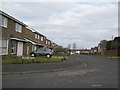
Westfields School Aycliffe
In this 1970's housing estate near Newton Aycliffe County Durham
Image: © Peter Robinson
Taken: 11 Mar 2010
0.20 miles