IMAGES TAKEN NEAR TO
St. Andrews Close, NEWTON AYCLIFFE, DL5 6NA
Introduction
This page details the photographs taken nearby to St. Andrews Close, DL5 6NA by members of the Geograph project.
The Geograph project started in 2005 with the aim of publishing, organising and preserving representative images for every square kilometre of Great Britain, Ireland and the Isle of Man.

There are currently over 7.5m images from over14,400 individuals and you can help contribute to the project by visiting https://www.geograph.org.uk
Image Map
Images are licensed for reuse under creativecommons.org/licenses/by-sa/2.0
Notes
- Clicking on the map will re-center to the selected point.
- The higher the marker number, the further away the image location is from the centre of the postcode.
Image Listing (20 Images Found)
Images are licensed for reuse under creativecommons.org/licenses/by-sa/2.0
Image
Details
Distance
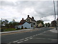
2
Ordnance Survey Cut Mark
This mark can be found on a roadside wall in High Street.
For more detail see : http://www.bench-marks.org.uk/bm45930
Image: © Peter Wood
Taken: 19 Oct 2012
0.06 miles
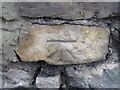
3
Ordnance Survey Flush Bracket S8805
This can be found on the wall of the North Briton (PH).
For more detail see : http://www.bench-marks.org.uk/bm21271
Image: © Peter Wood
Taken: 19 Oct 2012
0.08 miles
4
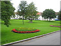
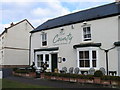
Aycliffe Village Green
There are often award winning floral displays in this County Durham village
Image: © Peter Robinson
Taken: 8 Jul 2009
0.08 miles
5
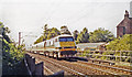
Down IC225 express on the ECML passing site of Aycliffe station, 1991
View southward, towards Darlington, York and the South: ex-NER section of the recently electrified East Coast Main Line. There was trace of the station, which had been closed nearly 40 years before, on 2/3/53. The train is running with DV trailer leading.
Image: © Ben Brooksbank
Taken: 7 Sep 1991
0.09 miles
7
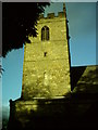
St Andrews Church Tower, Aycliffe Village
This lovely church is very rich in history and inside is full of some great items of historic interest.
Image: © Neil Atterby
Taken: 5 Nov 2005
0.10 miles
8

River Skerne Aycliffe Village
Flowing quietly through the village in County Durham
Image: © Peter Robinson
Taken: 8 Jul 2009
0.11 miles
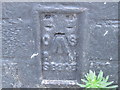
9
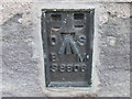
Ordnance Survey Flush Bracket S8806
This can be found on the wall of St Andrews Church.
For more detail see : http://www.bench-marks.org.uk/bm21272
Image: © Peter Wood
Taken: 19 Oct 2012
0.14 miles
10
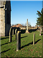
Graves and war memorial at Aycliffe
Aycliffe, is named as Aycliffe Village on OS maps, presumably to distinguish it from the large new town at nearby Newton Aycliffe. The church of St. Andrew lies to the south of the village and has a large surrounding cemetery; the graves seen here are at the east end of the building.
Image: © Trevor Littlewood
Taken: 8 Feb 2015
0.14 miles