IMAGES TAKEN NEAR TO
Burnhill Way, NEWTON AYCLIFFE, DL5 4PN
Introduction
This page details the photographs taken nearby to Burnhill Way, DL5 4PN by members of the Geograph project.
The Geograph project started in 2005 with the aim of publishing, organising and preserving representative images for every square kilometre of Great Britain, Ireland and the Isle of Man.

There are currently over 7.5m images from over14,400 individuals and you can help contribute to the project by visiting https://www.geograph.org.uk
Image Map
Images are licensed for reuse under creativecommons.org/licenses/by-sa/2.0
Notes
- Clicking on the map will re-center to the selected point.
- The higher the marker number, the further away the image location is from the centre of the postcode.
Image Listing (5 Images Found)
Images are licensed for reuse under creativecommons.org/licenses/by-sa/2.0
Image
Details
Distance
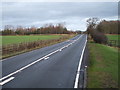
2
Middridge Road, Approaching Newton Aycliffe
Middridge Road, approaching Newton Aycliffe, with the golf course on the left hand side of the road.
Image: © David Dixon
Taken: 23 Jun 2011
0.14 miles
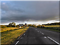
3
Entering Newton Aycliffe
Looking south west on Middridge Road.
Image: © JThomas
Taken: 28 Nov 2015
0.16 miles
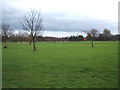
4
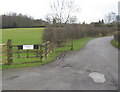
Road to Stotforth Hill Farm Windlestone County Durham
The entrance to this farm access route is off Middridge Lane
Image: © Peter Robinson
Taken: 27 Jan 2010
0.17 miles