IMAGES TAKEN NEAR TO
Wellhouse Road, NEWTON AYCLIFFE, DL5 4FF
Introduction
This page details the photographs taken nearby to Wellhouse Road, DL5 4FF by members of the Geograph project.
The Geograph project started in 2005 with the aim of publishing, organising and preserving representative images for every square kilometre of Great Britain, Ireland and the Isle of Man.

There are currently over 7.5m images from over14,400 individuals and you can help contribute to the project by visiting https://www.geograph.org.uk
Image Map
Images are licensed for reuse under creativecommons.org/licenses/by-sa/2.0
Notes
- Clicking on the map will re-center to the selected point.
- The higher the marker number, the further away the image location is from the centre of the postcode.
Image Listing (14 Images Found)
Images are licensed for reuse under creativecommons.org/licenses/by-sa/2.0
Image
Details
Distance
1
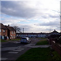
Mayfield Estate
Looking down Cambo Drive on the Mayfield Estate.
Image: © Carol Davenport
Taken: 8 Mar 2007
0.08 miles
2
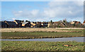
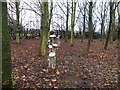
The Moor Nature Reserve
The Moor Nature Reserve as seen from Burnhill Way.
The view is westwards over this area which OS mapping declares to be a nature reserve. A little internet research however (January 2016) suggests that there have been problems with the development of the site which was supposed to use drainage water from the surrounding area to maintain the water level of the pool. There is apparently doubt that that is happening; although there's water for the pool at the time of writing, it's probably due to the deluge of rain experience in recent months.
Image: © Trevor Littlewood
Taken: 30 Jan 2016
0.11 miles
3
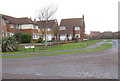
Rope Moor Way Newton Aycliffe County Durham
Built in the early 1990's in the northern area of the town
Image: © Peter Robinson
Taken: 27 Jan 2010
0.14 miles
5
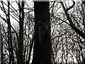
Toadstools on the Great Aycliffe Way
The Great Aycliffe Way is a five and a half mile walk that goes round and through Newton Aycliffe, with sculptures at various points.
Image: © malcolm tebbit
Taken: 8 Dec 2009
0.17 miles
6
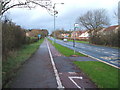
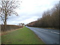
Dual use path beside Burn Lane
Heading north west.
Image: © JThomas
Taken: 28 Nov 2015
0.18 miles
7
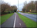
Dual use path beside Burn Lane
Heading north west.
Image: © JThomas
Taken: 28 Nov 2015
0.19 miles
9
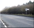
Junction for Eldon off Woodside Road
Between Newton Aycliffe and Rushyford.
Image: © Stanley Howe
Taken: 13 Apr 2013
0.23 miles