IMAGES TAKEN NEAR TO
SHILDON, DL4 2QB
Introduction
This page details the photographs taken nearby to DL4 2QB by members of the Geograph project.
The Geograph project started in 2005 with the aim of publishing, organising and preserving representative images for every square kilometre of Great Britain, Ireland and the Isle of Man.

There are currently over 7.5m images from over14,400 individuals and you can help contribute to the project by visiting https://www.geograph.org.uk
Image Map
Images are licensed for reuse under creativecommons.org/licenses/by-sa/2.0
Notes
- Clicking on the map will re-center to the selected point.
- The higher the marker number, the further away the image location is from the centre of the postcode.
Image Listing (7 Images Found)
Images are licensed for reuse under creativecommons.org/licenses/by-sa/2.0
Image
Details
Distance
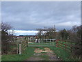
1
Footpath from Shildon to Redworth
This Public Right of Way is just over the southern boundary of County Durham and in Darlington Borough
Image: © Peter Robinson
Taken: 27 Jan 2010
0.12 miles
2
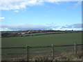
Farmland near Shildon
Looking west from the A6072 towards New House Farm.
Image: © JThomas
Taken: 6 Dec 2015
0.15 miles
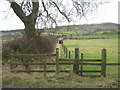
3
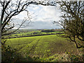
Field with emerging crop
The field lies to the south of Shildon and is seen through a gap in a hedge separating it from a narrow road which runs beside and parallel to the A6072.
Image: © Trevor Littlewood
Taken: 12 Nov 2015
0.19 miles

5
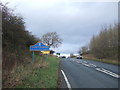
Entering County Durham
Heading north on the A6072.
Image: © JThomas
Taken: 6 Dec 2015
0.24 miles