IMAGES TAKEN NEAR TO
Coronation Avenue, SHILDON, DL4 2AA
Introduction
This page details the photographs taken nearby to Coronation Avenue, DL4 2AA by members of the Geograph project.
The Geograph project started in 2005 with the aim of publishing, organising and preserving representative images for every square kilometre of Great Britain, Ireland and the Isle of Man.

There are currently over 7.5m images from over14,400 individuals and you can help contribute to the project by visiting https://www.geograph.org.uk
Image Map
Images are licensed for reuse under creativecommons.org/licenses/by-sa/2.0
Notes
- Clicking on the map will re-center to the selected point.
- The higher the marker number, the further away the image location is from the centre of the postcode.
Image Listing (6 Images Found)
Images are licensed for reuse under creativecommons.org/licenses/by-sa/2.0
Image
Details
Distance
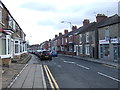
1
Middridge Lane : Shildon
Looking West
Image: © Hugh Mortimer
Taken: 26 Aug 2006
0.17 miles
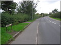
4
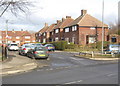
Sunnydale Shildon County Durham
Built in the 1930's and situated in the east of the town
Image: © Peter Robinson
Taken: 27 Jan 2010
0.22 miles
5
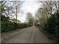
Old railway footpath, Shildon
A footpath in Shildon where an old railway line used to be.
Image: © Dylan Chester
Taken: 21 Mar 2021
0.24 miles