IMAGES TAKEN NEAR TO
Busty Terrace, SHILDON, DL4 1BG
Introduction
This page details the photographs taken nearby to Busty Terrace, DL4 1BG by members of the Geograph project.
The Geograph project started in 2005 with the aim of publishing, organising and preserving representative images for every square kilometre of Great Britain, Ireland and the Isle of Man.

There are currently over 7.5m images from over14,400 individuals and you can help contribute to the project by visiting https://www.geograph.org.uk
Image Map
Images are licensed for reuse under creativecommons.org/licenses/by-sa/2.0
Notes
- Clicking on the map will re-center to the selected point.
- The higher the marker number, the further away the image location is from the centre of the postcode.
Image Listing (11 Images Found)
Images are licensed for reuse under creativecommons.org/licenses/by-sa/2.0
Image
Details
Distance
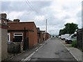
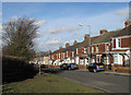
2
Adelaide Terrace
Terraced housing on the B6282.
Image: © JThomas
Taken: 13 Dec 2015
0.07 miles
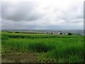
4
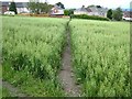
Cut path through a field of oats
Approaching Adelaide Bank, Shildon.
Image: © Oliver Dixon
Taken: 5 Jul 2007
0.12 miles
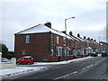
5
Adelaide Terrace, Shildon
Adelaide Terrace is a row of houses on the east side of Adelaide Bank (B6282) at the north end of the small town of Shildon in County Durham.
Image: © Trevor Littlewood
Taken: 3 Feb 2011
0.13 miles
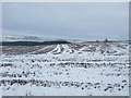
6
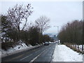
Adelaide Bank (B6282)
Heading north towards Bishop Auckland.
Image: © JThomas
Taken: 13 Dec 2015
0.14 miles
8
Agricultural Graveyard
Off Adelaide Bank, Shildon.
Image: © Oliver Dixon
Taken: 5 Jul 2007
0.19 miles
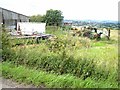
9
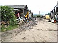
Farmyard near Shildon
A particularly scruffy farmyard off Adelaide Bank, Shildon.
Image: © Oliver Dixon
Taken: 5 Jul 2007
0.20 miles
10
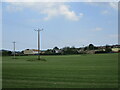
Telephone lines going across a farm near Shildon
Image: © Dylan Chester
Taken: 23 Jun 2022
0.24 miles