IMAGES TAKEN NEAR TO
Princes Street, SHILDON, DL4 1AX
Introduction
This page details the photographs taken nearby to Princes Street, DL4 1AX by members of the Geograph project.
The Geograph project started in 2005 with the aim of publishing, organising and preserving representative images for every square kilometre of Great Britain, Ireland and the Isle of Man.

There are currently over 7.5m images from over14,400 individuals and you can help contribute to the project by visiting https://www.geograph.org.uk
Image Map
Images are licensed for reuse under creativecommons.org/licenses/by-sa/2.0
Notes
- Clicking on the map will re-center to the selected point.
- The higher the marker number, the further away the image location is from the centre of the postcode.
Image Listing (16 Images Found)
Images are licensed for reuse under creativecommons.org/licenses/by-sa/2.0
Image
Details
Distance
3
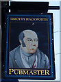
Sign for the Timothy Hackworth public house, Shildon
Image: © JThomas
Taken: 13 Dec 2015
0.10 miles
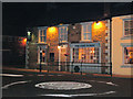
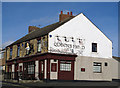
4
The Timothy Hackworth public house, Shildon
Timothy Hackworth (22 December 1786 – 7 July 1850) was a steam locomotive engineer who lived in Shildon, County Durham and was the first locomotive superintendent of the Stockton and Darlington Railway.
Image: © JThomas
Taken: 13 Dec 2015
0.11 miles
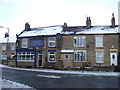
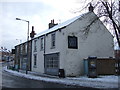
5
The Grey Horse, Byerley Road
This old Inn was the home of Daniel Adamson who operated a passenger service using a converted stagecoach on the tracks of the Stockton and Darlington Railway. This, the first public railroad in the world opened in 1825, but Daniel's involvement in what was to become the family 'travel agency' was short-lived as he died in 1832. He and his wife Nanny Gibson had sixteen children. The thirteenth child, Daniel III, who was a Civil and Mechanical engineer was the leading promoter of the Manchester Ship Canal Bill which gained Royal Assent in 1885. From the early days of the S&DR a branch known as the Surtees line passed the front door of the pub until the mid-20th century. On the day of the snapshot the photographer enjoyed the hospitality of the pub's B & B facilities. The pub has had several names.
In the 1841 Census it seems to have been known as Shildon Lodge, which was also the name of the coal-mine at the end of the back yard.
Link: https://www.g4fas.net/fmmmf.html
Image: © Geoff Royle
Taken: 12 Jun 2007
0.11 miles
7
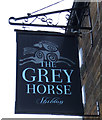
Sign for the Grey Horse, public house, Shildon
Image: © JThomas
Taken: 13 Dec 2015
0.12 miles
8
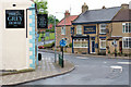
Byerley Road meets Main Street
Traffic is controlled at this T-junction with a 'fried-egg' roundabout.
The public house opposite is named after local hero Timothy Hackworth.
He was a famous locomotive designer/engineer who lived and worked in the town from 1825 to 1850.
The historic Grey Horse pub on the left has its own Geograph with comments, here : http://www.geograph.org.uk/photo/1109270
Image: © Geoff Royle
Taken: 13 Jun 2007
0.12 miles
9
The Queen's Head, Shildon
The Queen's Head lies on the east side of Adelaide Terrace, (B6282) in Shildon, County Durham.
Image: © Trevor Littlewood
Taken: 3 Feb 2011
0.13 miles
10
Old Railway Station
The historic Daniel Adamson's Coach House with its access arches now in-filled.
Image: © Kevin Waterhouse
Taken: 16 Apr 2023
0.13 miles